IMAGES TAKEN NEAR TO
Waverbridge, WIGTON, CA7 0EL
Introduction
This page details the photographs taken nearby to CA7 0EL by members of the Geograph project.
The Geograph project started in 2005 with the aim of publishing, organising and preserving representative images for every square kilometre of Great Britain, Ireland and the Isle of Man.

There are currently over 7.5m images from over14,400 individuals and you can help contribute to the project by visiting https://www.geograph.org.uk
Image Map
Images are licensed for reuse under creativecommons.org/licenses/by-sa/2.0
Notes
- Clicking on the map will re-center to the selected point.
- The higher the marker number, the further away the image location is from the centre of the postcode.
Image Listing (12 Images Found)
Images are licensed for reuse under creativecommons.org/licenses/by-sa/2.0
Image
Details
Distance
1
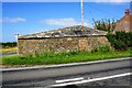
Building on NE side of B5302 at B5303 junction
There is an Ordnance Survey benchmark Image on the right hand corner of the building
Image: © Luke Shaw
Taken: 23 Jul 2019
0.01 miles
2
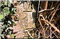
Benchmark on building at junction of B5302 and B5303
Ordnance Survey cut mark benchmark levelled at 27.693m above Newlyn Datum verified in 1972
Image: © Luke Shaw
Taken: 23 Jul 2019
0.02 miles
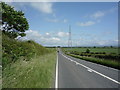
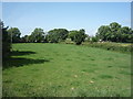
5
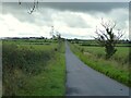
A straight road to Waverton
Across undulating farmland
Image: © Kevin Waterhouse
Taken: 23 Aug 2023
0.12 miles
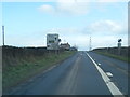
6
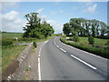
B5302, Waverbridge
Heading east towards Wigton.
Image: © JThomas
Taken: 18 Jun 2016
0.19 miles
7
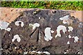
Benchmark on northern parapet of Waver Bridge
Ordnance Survey rivet benchmark levelled at 19.362m above Newlyn Datum verified in 1971
Image: © Luke Shaw
Taken: 23 Jul 2019
0.21 miles
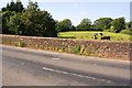
8
The road bridge at Waverbridge
Carries the B5302 road across the River Waver and has a long embankment on this approach from the east
Image: © Kevin Waterhouse
Taken: 23 Aug 2023
0.21 miles
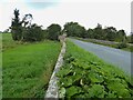
10
North parapet of Waver Bridge taking B5302 over River Waver
There is an Ordnance Survey benchmark Image on the top of the parapet left of the wooden pole in the field behind the parapet
Image: © Roger Templeman
Taken: 23 Jul 2019
0.22 miles