IMAGES TAKEN NEAR TO
WIGTON, CA7 0EG
Introduction
This page details the photographs taken nearby to CA7 0EG by members of the Geograph project.
The Geograph project started in 2005 with the aim of publishing, organising and preserving representative images for every square kilometre of Great Britain, Ireland and the Isle of Man.

There are currently over 7.5m images from over14,400 individuals and you can help contribute to the project by visiting https://www.geograph.org.uk
Image Map
Images are licensed for reuse under creativecommons.org/licenses/by-sa/2.0
Notes
- Clicking on the map will re-center to the selected point.
- The higher the marker number, the further away the image location is from the centre of the postcode.
Image Listing (24 Images Found)
Images are licensed for reuse under creativecommons.org/licenses/by-sa/2.0
Image
Details
Distance
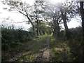
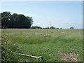
2
Public footpath from Longhead Farm
Looking north towards the crossing of the Wigton - Waverbridge road.
Image: © Christine Johnstone
Taken: 14 Oct 2014
0.07 miles
3
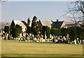
Sun and Shadows, Wigton Church and Cemetery
Image: © Bob Jenkins
Taken: 2 Mar 2006
0.07 miles
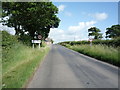
5
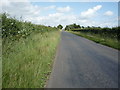
Minor road towards Wigton
Heading south east.
Image: © JThomas
Taken: 18 Jun 2016
0.10 miles
6
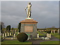
Wigton Cemetery
A view looking north within Wigton Cemetery, showing the memorial to William Banks.
Image: © Phil Williams
Taken: 16 Feb 2006
0.10 miles
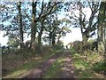
7
Public footpath to Longhead Farm
Looking south.
Image: © Christine Johnstone
Taken: 14 Oct 2014
0.10 miles
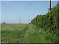
8
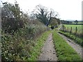
Public footpath from Aikhead, nearing Wigton cemetery
Looking south, along what is also the access track for Aikhead Low House.
Image: © Christine Johnstone
Taken: 14 Oct 2014
0.12 miles
10
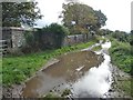
Public footpath from Aikhead to Station Hill
With a large puddle at the corner of the cemetery wall.
Image: © Christine Johnstone
Taken: 14 Oct 2014
0.13 miles