IMAGES TAKEN NEAR TO
Waverbridge, WIGTON, CA7 0DT
Introduction
This page details the photographs taken nearby to CA7 0DT by members of the Geograph project.
The Geograph project started in 2005 with the aim of publishing, organising and preserving representative images for every square kilometre of Great Britain, Ireland and the Isle of Man.

There are currently over 7.5m images from over14,400 individuals and you can help contribute to the project by visiting https://www.geograph.org.uk
Image Map
Images are licensed for reuse under creativecommons.org/licenses/by-sa/2.0
Notes
- Clicking on the map will re-center to the selected point.
- The higher the marker number, the further away the image location is from the centre of the postcode.
Image Listing (16 Images Found)
Images are licensed for reuse under creativecommons.org/licenses/by-sa/2.0
Image
Details
Distance
1
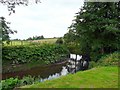
The River Waver at Waverbridge
Image: © Rose and Trev Clough
Taken: 12 Aug 2012
0.09 miles
2
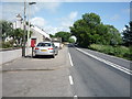
B5302, Waverbridge
Looking east showing position of Postbox No. CA7 206.
Image: © JThomas
Taken: 18 Jun 2016
0.10 miles
3
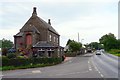
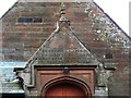
Former school, Waverbridge
Big steps lead to a door at first floor level. There is an inscription above it, dated 1844 - see Image .
According to an article written by the local Women's Institute http://www.visitoruk.com/historydetail.php?id=27114&cid=592&f=Carlisle , the school was built by Charles Ray of Lessonhall for 50 pupils, and closed in 1970. It is now a private house.
Image: © Rose and Trev Clough
Taken: 12 Aug 2012
0.10 miles
5
Bible quotation on porch of former schoolhouse
From Proverbs 22:6 - "Train up a child in the way he should go, and when he is old he will not depart from it".
Located on this building Image .
Image: © Rose and Trev Clough
Taken: 12 Aug 2012
0.10 miles
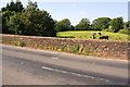
6
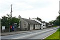
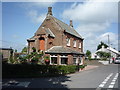
Part of the hamlet of Waverbridge
On the B5302 just west of Wigton.
Image: © Rose and Trev Clough
Taken: 12 Aug 2012
0.12 miles
7
Waverbridge
This solid sandstone bridge carries the B5303 over the River Waver (which drains into the Solway near Silloth) at the eponymously named Waverbridge.
Image: © Nigel Monckton
Taken: 2 Oct 2005
0.13 miles
8
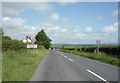
Entering Waverbridge
Heading east on the B5302.
Image: © JThomas
Taken: 18 Jun 2016
0.15 miles
9
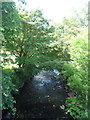
River Waver, Waverbridge
Looking north from the bridge on the B5302.
Image: © JThomas
Taken: 18 Jun 2016
0.16 miles
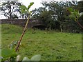
10
North parapet of Waver Bridge taking B5302 over River Waver
There is an Ordnance Survey benchmark Image on the top of the parapet left of the wooden pole in the field behind the parapet
Image: © Roger Templeman
Taken: 23 Jul 2019
0.16 miles