IMAGES TAKEN NEAR TO
Kellrigg, WIGTON, CA7 0DQ
Introduction
This page details the photographs taken nearby to Kellrigg, CA7 0DQ by members of the Geograph project.
The Geograph project started in 2005 with the aim of publishing, organising and preserving representative images for every square kilometre of Great Britain, Ireland and the Isle of Man.

There are currently over 7.5m images from over14,400 individuals and you can help contribute to the project by visiting https://www.geograph.org.uk
Image Map
Images are licensed for reuse under creativecommons.org/licenses/by-sa/2.0
Notes
- Clicking on the map will re-center to the selected point.
- The higher the marker number, the further away the image location is from the centre of the postcode.
Image Listing (9 Images Found)
Images are licensed for reuse under creativecommons.org/licenses/by-sa/2.0
Image
Details
Distance
2
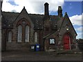
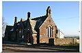
Blengogo, Former School
Blengogo, Former School
OS Benchmark on face of building
Image: © thejackrustles
Taken: 12 May 2018
0.02 miles
3
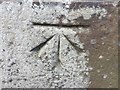
OS Cut Mark: Blengogo, Former School
CUT MARK: SCH NW FACE 9M N ANG (ODN 35.2501m, AGL 1.0m).
Image: © thejackrustles
Taken: 12 May 2018
0.02 miles
5
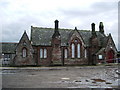
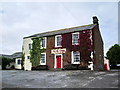
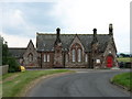
Old school, Blencogo
Now converted into the village hall
Image: © Alexander P Kapp
Taken: 20 Sep 2007
0.04 miles
6
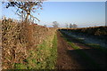
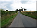
Footpath Blencogo
From Blencogo, looking towards Waverbridge.
Image: © Bob Jenkins
Taken: 29 Jan 2006
0.08 miles