IMAGES TAKEN NEAR TO
Woodrow, WIGTON, CA7 0AT
Introduction
This page details the photographs taken nearby to CA7 0AT by members of the Geograph project.
The Geograph project started in 2005 with the aim of publishing, organising and preserving representative images for every square kilometre of Great Britain, Ireland and the Isle of Man.

There are currently over 7.5m images from over14,400 individuals and you can help contribute to the project by visiting https://www.geograph.org.uk
Image Map
Images are licensed for reuse under creativecommons.org/licenses/by-sa/2.0
Notes
- Clicking on the map will re-center to the selected point.
- The higher the marker number, the further away the image location is from the centre of the postcode.
Image Listing (3 Images Found)
Images are licensed for reuse under creativecommons.org/licenses/by-sa/2.0
Image
Details
Distance
1
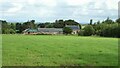
Woodrow Hall
View across the fields of the property that has outbuildings without roof tiles and at the other extreme solar panels on the house roof
Image: © Kevin Waterhouse
Taken: 23 Aug 2023
0.01 miles
2
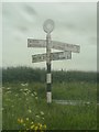
Direction Sign ? Signpost
Located on the northeast side of Woodrow crossroads in Waverton parish. 4 arms and annulus finial.
Milestone Society National ID: CU_NY2245
Image: © J Wickens
Taken: 5 Jun 2019
0.12 miles
3
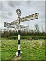
Direction Sign – Signpost at the Woodrow crossroads
Located on the northeast side of Woodrow crossroads in Waverton parish. 4 arms and annulus finial. See also https://www.geograph.org.uk/photo/6506637 , https://www.geograph.org.uk/photo/7712996 and https://www.geograph.org.uk/photo/7712999.
Milestone Society National ID: CU_NY2245
Image: © B Todd
Taken: 8 Apr 2024
0.12 miles