IMAGES TAKEN NEAR TO
Brookfields, WIGTON, CA7 0AF
Introduction
This page details the photographs taken nearby to Brookfields, CA7 0AF by members of the Geograph project.
The Geograph project started in 2005 with the aim of publishing, organising and preserving representative images for every square kilometre of Great Britain, Ireland and the Isle of Man.

There are currently over 7.5m images from over14,400 individuals and you can help contribute to the project by visiting https://www.geograph.org.uk
Image Map
Images are licensed for reuse under creativecommons.org/licenses/by-sa/2.0
Notes
- Clicking on the map will re-center to the selected point.
- The higher the marker number, the further away the image location is from the centre of the postcode.
Image Listing (20 Images Found)
Images are licensed for reuse under creativecommons.org/licenses/by-sa/2.0
Image
Details
Distance
1
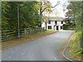
Brookfields, Wigton
A new road of new houses curling between the B5302 and Cuddy Lonning, on the site of the former Quaker School, alongside Black Beck.
Image: © Christine Johnstone
Taken: 14 Oct 2014
0.02 miles
2
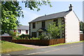
House on southeast side of Brookfields
Image: © Roger Templeman
Taken: 23 Jul 2019
0.02 miles
3
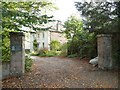
The former Friends School, Wigton, 1826 - 1985
I would never have identified this building, but for the plaque on the gatepost. Wigton School was opened by the Society of Friends (Quakers) at Highmoor in 1815. Permanent buildings were soon commissioned here at Brookfields, and these came into use in 1826. Student numbers peaked at around 210.The school closed in 1984, and the main buildings burnt down in January 1989. This part was the surgery and sick bay, with staff quarters above.
Image: © Christine Johnstone
Taken: 14 Oct 2014
0.03 miles
4
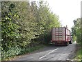
Cuddy Lonning, west of Wigton
Narrow lane, wide tractor and trailer. 'Lonning' is Cumbrian dialect for country lane, and 'cuddy' is dialect I think for donkey.
Image: © Christine Johnstone
Taken: 14 Oct 2014
0.05 miles
5
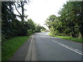
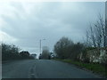
Heading south west from Wigton
On the B5302.
Image: © JThomas
Taken: 17 Sep 2016
0.05 miles
6
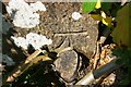
Benchmark on parapet of railway bridge on north side of B5302
Ordnance Survey cut mark benchmark levelled at 37.060m above Newlyn Datum and verified in 1970
Image: © Luke Shaw
Taken: 23 Jul 2019
0.06 miles
7
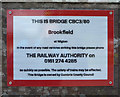
Sign on railway bridge on the B5302
Bridge No. CBC3/80.
Image: © JThomas
Taken: 17 Sep 2016
0.07 miles
8
Bridge carrying B5302 over railway at Cuddy Lonning junction
There is an Ordnance Survey benchmark Image on the right hand end, road face, of the bridge parapet which has identity CBC3/80 Image
Image: © Luke Shaw
Taken: 23 Jul 2019
0.07 miles
9
B5302 on bridge over railway near Brookfields
Image: © Colin Pyle
Taken: 28 Mar 2015
0.07 miles
10
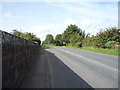
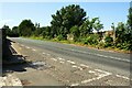
Heading west from Wigton
Crossing the railway bridge on the B5302.
Image: © JThomas
Taken: 17 Sep 2016
0.07 miles