IMAGES TAKEN NEAR TO
WIGTON, CA7 0AB
Introduction
This page details the photographs taken nearby to CA7 0AB by members of the Geograph project.
The Geograph project started in 2005 with the aim of publishing, organising and preserving representative images for every square kilometre of Great Britain, Ireland and the Isle of Man.

There are currently over 7.5m images from over14,400 individuals and you can help contribute to the project by visiting https://www.geograph.org.uk
Image Map
Images are licensed for reuse under creativecommons.org/licenses/by-sa/2.0
Notes
- Clicking on the map will re-center to the selected point.
- The higher the marker number, the further away the image location is from the centre of the postcode.
Image Listing (26 Images Found)
Images are licensed for reuse under creativecommons.org/licenses/by-sa/2.0
Image
Details
Distance
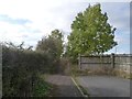
1
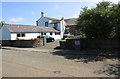
Entrance to Churchrigg from former A596
Image: © Roger Templeman
Taken: 23 Jul 2019
0.01 miles
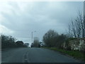
2
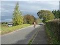
Heading east to Wigton
Cyclists on a tandem on the old main road. The lorry heading west is on the A596 by-pass.
Image: © Christine Johnstone
Taken: 14 Oct 2014
0.04 miles
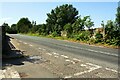
3
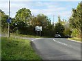
Don't turn first left for Workington
The old road west out of Wigton is now a no-through-road. All vehicles have to join the A596 by-pass.
Image: © Christine Johnstone
Taken: 14 Oct 2014
0.06 miles
4
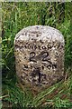
Old Milestone by the A596, west of Wigton
Carved stone post on North side of the modern A596, in parish of Wigton (Allerdale District), Church Rigg, in shrubs behind grass verge. Wigton curved red stone, erected by the Cockermouth & Maryport Turnpike Trust in the 19th century. It was originally located on the south side of the old road at Image and its benchmark levelled at 134.903 feet above Liverpool Datum during the 1843/4 1GL Kendal to Carlisle Survey
Inscription reads:-
WORKINGTON
22
WIGTON
1
Carved Ordnance Survey benchmark.
Milestone Society National ID: CU_WOWG22
Image: © CF Smith
Taken: 19 Feb 2010
0.07 miles
5
No Through Road by Church Rigg Farm
The old road west from Wigton ends abruptly, but the pavement continues towards the A596.
Image: © Christine Johnstone
Taken: 14 Oct 2014
0.08 miles
6
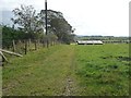
Sheep pasture with track, west of Church Rigg Farm
The fenced and hedged field boundary is also the boundary between Waverton and Wigton civil parishes.
Image: © Christine Johnstone
Taken: 14 Oct 2014
0.08 miles
7
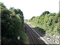
Railway towards Workington
Looking south west from the bridge on the B5302.
Image: © JThomas
Taken: 17 Sep 2016
0.09 miles
8
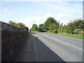
Heading west from Wigton
Crossing the railway bridge on the B5302.
Image: © JThomas
Taken: 17 Sep 2016
0.10 miles
9
B5302 on bridge over railway near Brookfields
Image: © Colin Pyle
Taken: 28 Mar 2015
0.10 miles
10
Bridge carrying B5302 over railway at Cuddy Lonning junction
There is an Ordnance Survey benchmark Image on the right hand end, road face, of the bridge parapet which has identity CBC3/80 Image
Image: © Luke Shaw
Taken: 23 Jul 2019
0.11 miles