IMAGES TAKEN NEAR TO
Roadhead, CARLISLE, CA6 6NS
Introduction
This page details the photographs taken nearby to CA6 6NS by members of the Geograph project.
The Geograph project started in 2005 with the aim of publishing, organising and preserving representative images for every square kilometre of Great Britain, Ireland and the Isle of Man.

There are currently over 7.5m images from over14,400 individuals and you can help contribute to the project by visiting https://www.geograph.org.uk
Image Map
Images are licensed for reuse under creativecommons.org/licenses/by-sa/2.0
Notes
- Clicking on the map will re-center to the selected point.
- The higher the marker number, the further away the image location is from the centre of the postcode.
Image Listing (8 Images Found)
Images are licensed for reuse under creativecommons.org/licenses/by-sa/2.0
Image
Details
Distance

2
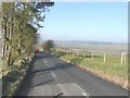
Westerly view from B6318
In the far distance there is the line of houses along Sleetback Road
Image: © John Baker
Taken: 28 Mar 2012
0.05 miles
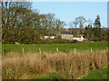
4
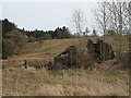
Mossend
Derelict building at Mossend.
Image: © Peter McDermott
Taken: 19 Jan 2008
0.19 miles
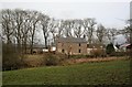
5
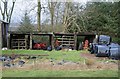
Snouts
Building constructed from timber railway sleepers at Snouts Farm.
Image: © Peter McDermott
Taken: 19 Jan 2008
0.21 miles
6
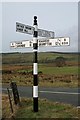
Sign Post
Well maintained old style sign post on the B6318 near Roadhead.
Image: © Peter McDermott
Taken: 19 Jan 2008
0.22 miles