IMAGES TAKEN NEAR TO
Roadhead, CARLISLE, CA6 6NF
Introduction
This page details the photographs taken nearby to CA6 6NF by members of the Geograph project.
The Geograph project started in 2005 with the aim of publishing, organising and preserving representative images for every square kilometre of Great Britain, Ireland and the Isle of Man.

There are currently over 7.5m images from over14,400 individuals and you can help contribute to the project by visiting https://www.geograph.org.uk
Image Map
Images are licensed for reuse under creativecommons.org/licenses/by-sa/2.0
Notes
- Clicking on the map will re-center to the selected point.
- The higher the marker number, the further away the image location is from the centre of the postcode.
Image Listing (10 Images Found)
Images are licensed for reuse under creativecommons.org/licenses/by-sa/2.0
Image
Details
Distance
3
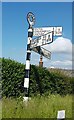
Old Direction Sign - Signpost by the B6318, Roadhead
Annulus finial - 3 arms; Cumberland named halo by the B6318, in parish of Bewcastle (Carlisle District), T-junction at Roadhead, on grass verge, against hedge.
To be surveyed
Milestone Society National ID: CU_NY5174
Image: © Milestone Society
Taken: Unknown
0.16 miles
4
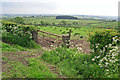
View over countryside near Roadhead
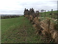
Rough grazing land sloping down to the Whitberry Burn.
A skylark was singing loudly and continuously above this field.
Image: © Rose and Trev Clough
Taken: 1 Jun 2014
0.16 miles
6
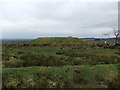
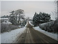
Kinkry Hill Road, Roadhead
A tiny village in the remote north-eastern corner of Cumbria.
Image: © Oliver Dixon
Taken: 5 Sep 2007
0.19 miles
8
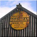
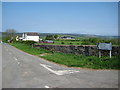
Old AA Sign on the B6318 in Roadhead
Old AA Sign located on the corrugated gable end of an old garage on the southeast side of the B6318 in Roadhead, 14 miles northeast of Carlisle. Bewcastle parish.
This is the Circular, village name on black band, no Motor Union symbol or name type, dating from 1923, showing distances Newcastleton 9 Lyneholme Ford 2 London 306½. Last visible on Street View in 2010.
There were five series of AA signs, mostly dating from 1923 and made by Francis & Co / Franco in Deptford, London. The village name and distance to London were displayed.
Milestone Society National ID: CB-ROADH
Image: © Milestone Society
Taken: Unknown
0.20 miles
9
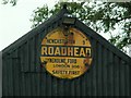
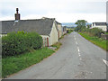
Old AA sign on shed at Roadhead
Image: © Rose and Trev Clough
Taken: 11 Aug 2007
0.21 miles