IMAGES TAKEN NEAR TO
Hethersgill, CARLISLE, CA6 6JA
Introduction
This page details the photographs taken nearby to CA6 6JA by members of the Geograph project.
The Geograph project started in 2005 with the aim of publishing, organising and preserving representative images for every square kilometre of Great Britain, Ireland and the Isle of Man.

There are currently over 7.5m images from over14,400 individuals and you can help contribute to the project by visiting https://www.geograph.org.uk
Image Map
Images are licensed for reuse under creativecommons.org/licenses/by-sa/2.0
Notes
- Clicking on the map will re-center to the selected point.
- The higher the marker number, the further away the image location is from the centre of the postcode.
Image Listing (5 Images Found)
Images are licensed for reuse under creativecommons.org/licenses/by-sa/2.0
Image
Details
Distance
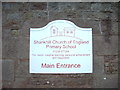
2
Shankhill Church of England Primary School
Stuck out on a cross-roads in the middle of nowhere, far from the nearest village.
Image: © Oliver Dixon
Taken: 24 Sep 2006
0.03 miles
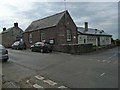
3
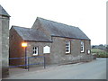
Shankhill Church of England Primary School
What was once a small country school now has two large extensions, both of which are larger than the original school
Image: © Alexander P Kapp
Taken: 2 Mar 2007
0.04 miles
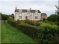
5
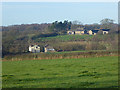
Middlefoot Farm
With Smithsteads Farm Image beyond.
Image: © Oliver Dixon
Taken: 30 Nov 2014
0.21 miles