IMAGES TAKEN NEAR TO
Hethersgill, CARLISLE, CA6 6HW
Introduction
This page details the photographs taken nearby to CA6 6HW by members of the Geograph project.
The Geograph project started in 2005 with the aim of publishing, organising and preserving representative images for every square kilometre of Great Britain, Ireland and the Isle of Man.

There are currently over 7.5m images from over14,400 individuals and you can help contribute to the project by visiting https://www.geograph.org.uk
Image Map
Images are licensed for reuse under creativecommons.org/licenses/by-sa/2.0
Notes
- Clicking on the map will re-center to the selected point.
- The higher the marker number, the further away the image location is from the centre of the postcode.
Image Listing (7 Images Found)
Images are licensed for reuse under creativecommons.org/licenses/by-sa/2.0
Image
Details
Distance

3
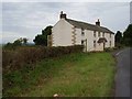
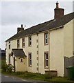
Fell House, Boltonfellend
I believe that this house was formerly the village pub.
Image: © Oliver Dixon
Taken: 24 Sep 2006
0.17 miles
4
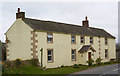
Former "Pointer Dog Inn" - Boltonfellend - April 2017 (1)
Dating from before the 1865 OS Map, the Pointer Dog Inn was acquired by the State Management Scheme in April 1917. Sold by the SMS in 1973 for £5,500, it was later closed (exact date not known) and is now a private dwelling.
See also: Image] and Image] .
Image: © The Carlisle Kid
Taken: 6 Apr 2017
0.23 miles
5
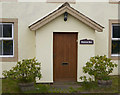
Former "Pointer Dog Inn" - Boltonfellend - April 2017 (2)
Entrance - the owners have retained a link with the past.
For information on this building, see: Image] .
Image: © The Carlisle Kid
Taken: 6 Apr 2017
0.23 miles
6
Former "Pointer Dog Inn" - Boltonfellend - April 2017 (3)
For information on this building, see: Image] .
Image: © The Carlisle Kid
Taken: 6 Apr 2017
0.23 miles
7
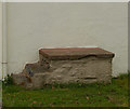
Former "Pointer Dog Inn" - Boltonfellend - April 2017 (4)
Steps attached to a "new" extension to the former pub - possibly horse mounting steps or entrance to a long demolished barn.
For information on the building, see: Image] .
Image: © The Carlisle Kid
Taken: 6 Apr 2017
0.24 miles