IMAGES TAKEN NEAR TO
Hethersgill, CARLISLE, CA6 6HT
Introduction
This page details the photographs taken nearby to CA6 6HT by members of the Geograph project.
The Geograph project started in 2005 with the aim of publishing, organising and preserving representative images for every square kilometre of Great Britain, Ireland and the Isle of Man.

There are currently over 7.5m images from over14,400 individuals and you can help contribute to the project by visiting https://www.geograph.org.uk
Image Map
Images are licensed for reuse under creativecommons.org/licenses/by-sa/2.0
Notes
- Clicking on the map will re-center to the selected point.
- The higher the marker number, the further away the image location is from the centre of the postcode.
Image Listing (7 Images Found)
Images are licensed for reuse under creativecommons.org/licenses/by-sa/2.0
Image
Details
Distance
1
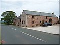
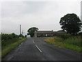
Newlands Farm, Boltonfellend
Now converted to holiday cottages.
Image: © Oliver Dixon
Taken: 24 Sep 2006
0.16 miles
2
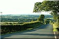
View towards the Lyne Valley from Boltonfellend
Taken from beside Image .
Image: © Rose and Trev Clough
Taken: 29 Jun 2007
0.21 miles
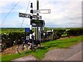
7
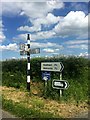
Old and New
The old type CCC signpost versus the more modern sign of today, in my mind no competition.
Image: © David Liddle
Taken: 30 Jun 2015
0.24 miles