IMAGES TAKEN NEAR TO
Kirklinton, CARLISLE, CA6 6DB
Introduction
This page details the photographs taken nearby to CA6 6DB by members of the Geograph project.
The Geograph project started in 2005 with the aim of publishing, organising and preserving representative images for every square kilometre of Great Britain, Ireland and the Isle of Man.

There are currently over 7.5m images from over14,400 individuals and you can help contribute to the project by visiting https://www.geograph.org.uk
Image Map
Images are licensed for reuse under creativecommons.org/licenses/by-sa/2.0
Notes
- Clicking on the map will re-center to the selected point.
- The higher the marker number, the further away the image location is from the centre of the postcode.
Image Listing (8 Images Found)
Images are licensed for reuse under creativecommons.org/licenses/by-sa/2.0
Image
Details
Distance
1
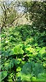
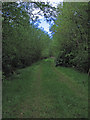
Overgrown footpath on south side of River Lyne
Image: © Roger Templeman
Taken: 4 Jun 2021
0.17 miles
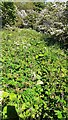
2
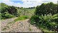
Field gateway on south side of rural road opposite Sawmill Wood
Image: © Roger Templeman
Taken: 4 Jun 2021
0.19 miles
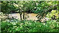
4
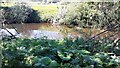
View across River Lyne from footpath running along its south bank
Image: © Luke Shaw
Taken: 4 Jun 2021
0.21 miles
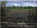
6
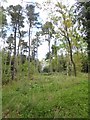
Woodland near Haggiston Holme
Straggling Scots Pine and other trees.
Image: © Oliver Dixon
Taken: 10 May 2019
0.25 miles
7
Overgrown footpath along south side of River Lyne opposite Haggistone Holm
Image: © Luke Shaw
Taken: 4 Jun 2021
0.25 miles
8
View from footpath across River Lyne towards Haggistone Holm
Image: © Roger Templeman
Taken: 4 Jun 2021
0.25 miles