IMAGES TAKEN NEAR TO
Oak Avenue, CARLISLE, CA6 5WF
Introduction
This page details the photographs taken nearby to Oak Avenue, CA6 5WF by members of the Geograph project.
The Geograph project started in 2005 with the aim of publishing, organising and preserving representative images for every square kilometre of Great Britain, Ireland and the Isle of Man.

There are currently over 7.5m images from over14,400 individuals and you can help contribute to the project by visiting https://www.geograph.org.uk
Image Map (Loading...)


Getting Data...Please wait
Leaflet Map data © OpenStreetMap
Images are licensed for reuse under creativecommons.org/licenses/by-sa/2.0
Notes
- Clicking on the map will re-center to the selected point.
- The higher the marker number, the further away the image location is from the centre of the postcode.
Image Listing (121 Images Found)
Images are licensed for reuse under creativecommons.org/licenses/by-sa/2.0
Image
Details
Distance
1
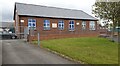
Pear Tree Nursery
There is an Ordnance Survey benchmark Image on the left hand side of the school at its front corner
Image: © Roger Templeman
Taken: 4 May 2021
0.08 miles
2
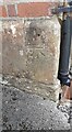
Benchmark on Pear Tree Nursery
Ordnance Survey cut mark benchmark levelled at 20.504m above Newlyn Datum verified in 1955
Image: © Roger Templeman
Taken: 4 May 2021
0.09 miles
3
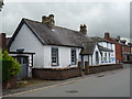
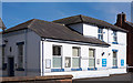
Building beside the Police Station
Dates from pre-1901 and associated with the Police Station.
Image: © John M
Taken: 24 Aug 2017
0.09 miles
4
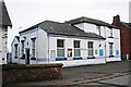
Longtown Police Station
The Longtown area is covered by police officers based at Brampton. Longtown Police Station, located in Graham Street, is still used by officers but the public enquiry desk is currently closed (see Cumbria Constabulary website http://www.cumbria.police.uk/neighbourhood-overview/longtown#contact ).
Image: © Rose and Trev Clough
Taken: 4 Feb 2015
0.10 miles
5
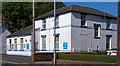
Longtown Police Station - May 2017 (1)
Situated on Netherby Road, it has the appearance of a mid-20th Century structure.
Seems deserted with uncertain opening hours - see: Image], Image], Image] and Image] .
Image: © The Carlisle Kid
Taken: 31 May 2017
0.10 miles
6
Longtown Police Station - May 2017 (2)
See also: Image] .
Image: © The Carlisle Kid
Taken: 31 May 2017
0.10 miles
7
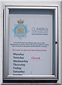
Longtown Police Station - May 2017 (3)
Notice on the station giving details of opening hours!
See also: Image] .
Image: © The Carlisle Kid
Taken: 31 May 2017
0.10 miles
8
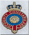
Longtown Police Station - May 2017 (4)
Crest over the public entrance to the station.
See also: Image] .
Image: © The Carlisle Kid
Taken: 31 May 2017
0.10 miles
9
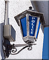
Longtown Police Station - May 2017 (5)
The blue lamp!
See also: Image] .
Image: © The Carlisle Kid
Taken: 31 May 2017
0.10 miles
10
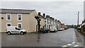
Graham Street
Graham Street is the extension, at an angle, of Netherby Street. It is the way to Netherby, which is the seat of the Graham family.
Image: © Anne Burgess
Taken: 3 Jan 2023
0.10 miles