IMAGES TAKEN NEAR TO
Longtown, CARLISLE, CA6 5TW
Introduction
This page details the photographs taken nearby to CA6 5TW by members of the Geograph project.
The Geograph project started in 2005 with the aim of publishing, organising and preserving representative images for every square kilometre of Great Britain, Ireland and the Isle of Man.

There are currently over 7.5m images from over14,400 individuals and you can help contribute to the project by visiting https://www.geograph.org.uk
Image Map
Images are licensed for reuse under creativecommons.org/licenses/by-sa/2.0
Notes
- Clicking on the map will re-center to the selected point.
- The higher the marker number, the further away the image location is from the centre of the postcode.
Image Listing (5 Images Found)
Images are licensed for reuse under creativecommons.org/licenses/by-sa/2.0
Image
Details
Distance
1
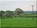
Hallburn Farm
The farm occupies the site of the old World War II Longtown airfield where RAF 44 Group Transport OTU were based.
Image: © Oliver Dixon
Taken: 29 Apr 2011
0.08 miles
2
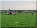
Hallburn Farm
The farm occupies the site of the old World War II Longtown airfield where RAF 44 Group Transport OTU were based. The concrete building in the foreground is a relic dating from that time.
Image: © Oliver Dixon
Taken: 29 Apr 2011
0.12 miles
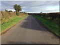
4

Whingate
The road near Hallburn, five years after Image
Image: © Richard Webb
Taken: 4 Apr 2019
0.19 miles