IMAGES TAKEN NEAR TO
Longtown, CARLISLE, CA6 5TR
Introduction
This page details the photographs taken nearby to CA6 5TR by members of the Geograph project.
The Geograph project started in 2005 with the aim of publishing, organising and preserving representative images for every square kilometre of Great Britain, Ireland and the Isle of Man.

There are currently over 7.5m images from over14,400 individuals and you can help contribute to the project by visiting https://www.geograph.org.uk
Image Map
Images are licensed for reuse under creativecommons.org/licenses/by-sa/2.0
Notes
- Clicking on the map will re-center to the selected point.
- The higher the marker number, the further away the image location is from the centre of the postcode.
Image Listing (19 Images Found)
Images are licensed for reuse under creativecommons.org/licenses/by-sa/2.0
Image
Details
Distance
1
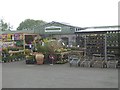
Whitesike Garden Centre
Garden centre and cafe beside the A6071.
Image: © Oliver Dixon
Taken: 10 May 2019
0.01 miles
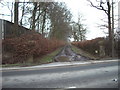
3
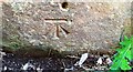
Benchmark on SW parapet of Whitesike Bridge
Ordnance Survey cut mark benchmark levelled at 21.943m above Newlyn Datum in 1971 and verified in 1974
Image: © Roger Templeman
Taken: 4 Jun 2021
0.06 miles
4

Stone plaque on SW parapet of Whitesike Bridge
The plaque has Milestone Society National ID: CU_ARTHUR03br
Image: © Roger Templeman
Taken: 4 Jun 2021
0.06 miles
5

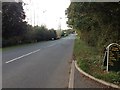
Parapet of Whitesike Bridge on SW side of A6071
There is an Ordnance Survey benchmark Image on a stone in the parapet wall near the left hand edge of the image, and a bridge name plaque Image as the stone right of the stone with the benchmark
Image: © Roger Templeman
Taken: 4 Jun 2021
0.09 miles
6

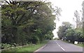
Polythene landscape near Longtown
The polythene warms the soil, in which maize has been sown. When harvested it will go to an anaerobic digester to produce methane https://en.wikipedia.org/wiki/Anaerobic_digestion?msclkid=adb03555c6f511ecbf8c925041f224d , which can be used as a fuel. Beyond are poultry houses at Lynemoor.
Image: © M J Richardson
Taken: 26 Apr 2022
0.13 miles
8
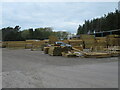
Timber yard near Longtown
A useful place for anything wood related.
Image: © M J Richardson
Taken: 26 Apr 2022
0.20 miles
10
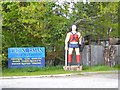
Chainsaw maiden
Standing outside a timber yard on the A6071 at Lynemoor.
Image: © Oliver Dixon
Taken: 10 May 2019
0.22 miles