IMAGES TAKEN NEAR TO
Woodside, CARLISLE, CA6 5SP
Introduction
This page details the photographs taken nearby to Woodside, CA6 5SP by members of the Geograph project.
The Geograph project started in 2005 with the aim of publishing, organising and preserving representative images for every square kilometre of Great Britain, Ireland and the Isle of Man.

There are currently over 7.5m images from over14,400 individuals and you can help contribute to the project by visiting https://www.geograph.org.uk
Image Map
Images are licensed for reuse under creativecommons.org/licenses/by-sa/2.0
Notes
- Clicking on the map will re-center to the selected point.
- The higher the marker number, the further away the image location is from the centre of the postcode.
Image Listing (24 Images Found)
Images are licensed for reuse under creativecommons.org/licenses/by-sa/2.0
Image
Details
Distance
1
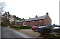
Houses, Woodside
On National Cycle Route 7.
Image: © JThomas
Taken: 20 Nov 2019
0.01 miles
3
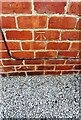
Benchmark on Hornickhill Cottages
Ordnance Survey cut mark benchmark levelled at 13.085m above Newlyn Datum verified in 1974
Image: © Roger Templeman
Taken: 1 Jun 2021
0.08 miles
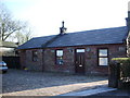
4
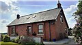
Hornikhill Cottages
Appears to be a single dwelling now. There is an Ordnance Survey benchmark Image on the right hand side of the house near its front corner
Image: © Roger Templeman
Taken: 1 Jun 2021
0.09 miles
5
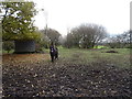
Paddock, Woodside
Off National Cycle Route 7.
Image: © JThomas
Taken: 20 Nov 2019
0.09 miles
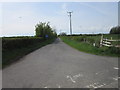
6
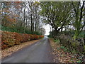
National Cycle Route 7, Woodside
Towards Carlisle.
Image: © JThomas
Taken: 20 Nov 2019
0.11 miles
7
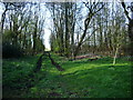
Track on the course of the dismantled railway at Fauldmoor Crossing
Image: © Alexander P Kapp
Taken: 23 Apr 2008
0.12 miles
9
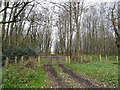
Track into woodland
Off National Cycle Route 7.
Image: © JThomas
Taken: 20 Nov 2019
0.13 miles
10

Benchmark on Brickworks Cottage
Ordnance Survey cut mark benchmark levelled at 12.838m above Newlyn Datum verified 1974
Image: © Roger Templeman
Taken: 1 Jun 2021
0.14 miles