IMAGES TAKEN NEAR TO
Easton, Longtown, CARLISLE, CA6 5RR
Introduction
This page details the photographs taken nearby to CA6 5RR by members of the Geograph project.
The Geograph project started in 2005 with the aim of publishing, organising and preserving representative images for every square kilometre of Great Britain, Ireland and the Isle of Man.

There are currently over 7.5m images from over14,400 individuals and you can help contribute to the project by visiting https://www.geograph.org.uk
Image Map
Images are licensed for reuse under creativecommons.org/licenses/by-sa/2.0
Notes
- Clicking on the map will re-center to the selected point.
- The higher the marker number, the further away the image location is from the centre of the postcode.
Image Listing (3 Images Found)
Images are licensed for reuse under creativecommons.org/licenses/by-sa/2.0
Image
Details
Distance
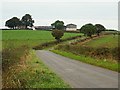
2
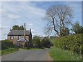
House at Easton
The Village Hall lies immediately beyond. Chapeltown Farm can be seen in the distance.
Image: © Oliver Dixon
Taken: 10 May 2019
0.20 miles
3
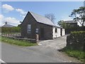
Easton Village Hall
An old school, closed about 1956, now serves as a village hall for the tiny community of Easton.
Image: © Oliver Dixon
Taken: 10 May 2019
0.22 miles