IMAGES TAKEN NEAR TO
Longtown, CARLISLE, CA6 5RH
Introduction
This page details the photographs taken nearby to CA6 5RH by members of the Geograph project.
The Geograph project started in 2005 with the aim of publishing, organising and preserving representative images for every square kilometre of Great Britain, Ireland and the Isle of Man.

There are currently over 7.5m images from over14,400 individuals and you can help contribute to the project by visiting https://www.geograph.org.uk
Image Map
Images are licensed for reuse under creativecommons.org/licenses/by-sa/2.0
Notes
- Clicking on the map will re-center to the selected point.
- The higher the marker number, the further away the image location is from the centre of the postcode.
Image Listing (9 Images Found)
Images are licensed for reuse under creativecommons.org/licenses/by-sa/2.0
Image
Details
Distance
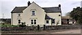
2
Cows feeding in barn at Oakshaw Hill
Image: © Roger Templeman
Taken: 14 Apr 2022
0.01 miles
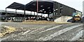
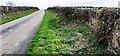
4

Road
Oakshaw Hill and a road in a poor state of repair. It really is little more than a drive for the farm, so not surprisingly low on Cumbria County Council's repair rota.
Image: © Richard Webb
Taken: 13 Feb 2019
0.10 miles
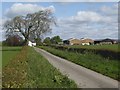
5
Hedge-lined minor road approaching Oakshaw Hill
Looking south-eastward.
Image: © Peter Wood
Taken: 25 Sep 2021
0.13 miles
6
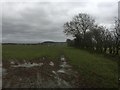
Mud
A muddy field, Oakshaw Head. Mild weather in February.
Image: © Richard Webb
Taken: 13 Feb 2019
0.13 miles
7
Rural road north of Oakshaw Hill with celendine on verge
Image: © Luke Shaw
Taken: 14 Apr 2022
0.15 miles
8

Celandine on western verge of road north of Oakshaw Hill
Image: © Roger Templeman
Taken: 14 Apr 2022
0.19 miles
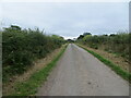
9
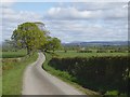
Road north of Oakshaw Hill
The road runs between two neatly maintained beech hedges. Hills across the Scottish border on the skyline.
Image: © Oliver Dixon
Taken: 10 May 2019
0.19 miles