IMAGES TAKEN NEAR TO
Penton, CARLISLE, CA6 5QX
Introduction
This page details the photographs taken nearby to CA6 5QX by members of the Geograph project.
The Geograph project started in 2005 with the aim of publishing, organising and preserving representative images for every square kilometre of Great Britain, Ireland and the Isle of Man.

There are currently over 7.5m images from over14,400 individuals and you can help contribute to the project by visiting https://www.geograph.org.uk
Image Map
Images are licensed for reuse under creativecommons.org/licenses/by-sa/2.0
Notes
- Clicking on the map will re-center to the selected point.
- The higher the marker number, the further away the image location is from the centre of the postcode.
Image Listing (5 Images Found)
Images are licensed for reuse under creativecommons.org/licenses/by-sa/2.0
Image
Details
Distance
1
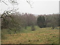
Embankment of the former Waverley line
Image: © Jonathan Thacker
Taken: 1 Apr 2016
0.05 miles
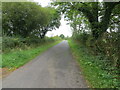
2
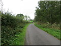
Tree and hedge enclosed minor road near to Haithwaite
Looking south-westward.
Image: © Peter Wood
Taken: 25 Sep 2021
0.06 miles
3
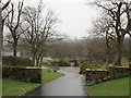
Driveway leading to an overbridge of the former Waverley line
Image: © Jonathan Thacker
Taken: 1 Apr 2016
0.10 miles
4
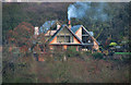
Shankend
Large house above Liddel Water.
Image: © Peter McDermott
Taken: 12 Nov 2011
0.12 miles
5
Tree and hedge enclosed minor road near to Haithwaite
Looking north-eastward.
Image: © Peter Wood
Taken: 25 Sep 2021
0.19 miles