IMAGES TAKEN NEAR TO
Bushfield, CARLISLE, CA6 5QJ
Introduction
This page details the photographs taken nearby to Bushfield, CA6 5QJ by members of the Geograph project.
The Geograph project started in 2005 with the aim of publishing, organising and preserving representative images for every square kilometre of Great Britain, Ireland and the Isle of Man.

There are currently over 7.5m images from over14,400 individuals and you can help contribute to the project by visiting https://www.geograph.org.uk
Image Map
Images are licensed for reuse under creativecommons.org/licenses/by-sa/2.0
Notes
- Clicking on the map will re-center to the selected point.
- The higher the marker number, the further away the image location is from the centre of the postcode.
Image Listing (4 Images Found)
Images are licensed for reuse under creativecommons.org/licenses/by-sa/2.0
Image
Details
Distance
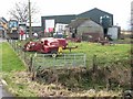
1
Bushfield
A series of houses and farms strung out along a narrow road. The higher ground here is nearly all forested.
Image: © Richard Webb
Taken: 4 Aug 2008
0.02 miles
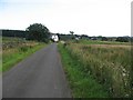
2
Road from Stonegarthside to Bushfield
Image: © Rose and Trev Clough
Taken: 9 Sep 2007
0.04 miles
3
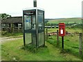
Telephone and pillar boxes at Bushfield
Image: © Rose and Trev Clough
Taken: 9 Sep 2007
0.12 miles