IMAGES TAKEN NEAR TO
Penton, CARLISLE, CA6 5QG
Introduction
This page details the photographs taken nearby to CA6 5QG by members of the Geograph project.
The Geograph project started in 2005 with the aim of publishing, organising and preserving representative images for every square kilometre of Great Britain, Ireland and the Isle of Man.

There are currently over 7.5m images from over14,400 individuals and you can help contribute to the project by visiting https://www.geograph.org.uk
Image Map
Images are licensed for reuse under creativecommons.org/licenses/by-sa/2.0
Notes
- Clicking on the map will re-center to the selected point.
- The higher the marker number, the further away the image location is from the centre of the postcode.
Image Listing (10 Images Found)
Images are licensed for reuse under creativecommons.org/licenses/by-sa/2.0
Image
Details
Distance
1
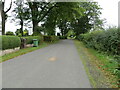
Minor road at Stoneygate
Looking north-eastward.
Image: © Peter Wood
Taken: 25 Sep 2021
0.01 miles
2
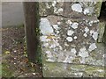
Ordnance Survey Cut Mark
This mark can be found on the corner of a roadside wall at Stonygate.
The recorded details give a height of 124.142 metres above sea level.
For more details see : https://www.bench-marks.org.uk/bm164656
Image: © Peter Wood
Taken: 25 Sep 2021
0.04 miles
3
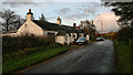
Blacksmith's Cottage
Blacksmith's Cottage at Stonygate.
Image: © Peter McDermott
Taken: 12 Nov 2011
0.08 miles
4

Blacksmith's Cottage
The shadow is not that of the photographer but of the chimney stack on Stonygate, the house on the other side of the road.
Image: © Oliver Dixon
Taken: 9 Feb 2008
0.09 miles
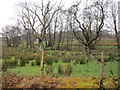
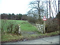
5
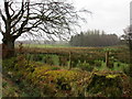
View towards Birney Wood
On a dank day.
Image: © Jonathan Thacker
Taken: 1 Apr 2016
0.16 miles
8
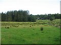
Damp farmland, Kingfield
Wet ground with rushes.
Image: © Richard Webb
Taken: 4 Aug 2008
0.21 miles
9
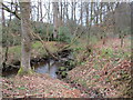
Black Burn
I assume it is Black Burn as it runs through Blackburn Wood, though OS seems uncertain about that as at some scales it is marked Backburn Wood.
Image: © Jonathan Thacker
Taken: 1 Apr 2016
0.22 miles
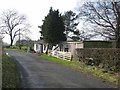
10
Easy access
The road sign asks the motorist to be careful and not to run over the red squirrels
Image: © Alexander P Kapp
Taken: 23 Jan 2007
0.22 miles