IMAGES TAKEN NEAR TO
Longtown, CARLISLE, CA6 5PZ
Introduction
This page details the photographs taken nearby to CA6 5PZ by members of the Geograph project.
The Geograph project started in 2005 with the aim of publishing, organising and preserving representative images for every square kilometre of Great Britain, Ireland and the Isle of Man.

There are currently over 7.5m images from over14,400 individuals and you can help contribute to the project by visiting https://www.geograph.org.uk
Image Map
Images are licensed for reuse under creativecommons.org/licenses/by-sa/2.0
Notes
- Clicking on the map will re-center to the selected point.
- The higher the marker number, the further away the image location is from the centre of the postcode.
Image Listing (5 Images Found)
Images are licensed for reuse under creativecommons.org/licenses/by-sa/2.0
Image
Details
Distance


3
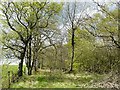
Skurrlywarble Wood
A brilliant name, we have no idea what it means. Deciduous woodland, mainly birch at this end. A public footpath runs along the inside of the fence.
Image: © Rose and Trev Clough
Taken: 3 May 2010
0.15 miles