IMAGES TAKEN NEAR TO
Longtown, CARLISLE, CA6 5PA
Introduction
This page details the photographs taken nearby to CA6 5PA by members of the Geograph project.
The Geograph project started in 2005 with the aim of publishing, organising and preserving representative images for every square kilometre of Great Britain, Ireland and the Isle of Man.

There are currently over 7.5m images from over14,400 individuals and you can help contribute to the project by visiting https://www.geograph.org.uk
Image Map
Images are licensed for reuse under creativecommons.org/licenses/by-sa/2.0
Notes
- Clicking on the map will re-center to the selected point.
- The higher the marker number, the further away the image location is from the centre of the postcode.
Image Listing (15 Images Found)
Images are licensed for reuse under creativecommons.org/licenses/by-sa/2.0
Image
Details
Distance
1
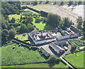
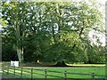
Crofthead
Attractive, pink painted farmhouse dwellings in the middle of grid square.
Image: © Simon Ledingham
Taken: 30 Sep 2006
0.02 miles
2
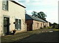
Cottage and old farm building, Crofthead
Image: © Rose and Trev Clough
Taken: 22 Sep 2007
0.03 miles
3
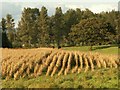
Crop field and cattle, Crofthead
Unable to get close enough to identify this crop - possibly a legume?
Image: © Rose and Trev Clough
Taken: 22 Sep 2007
0.06 miles
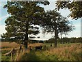
4
Mature beech trees at Crofthead
Crofthead is part of the Netherby Estate.
Image: © Rose and Trev Clough
Taken: 22 Sep 2007
0.10 miles
5
Farmland at Crofthead
Crofthead is part of the Netherby Estate, which has been owned by the Graham family for 400 years. www.netherbyestate.co.uk/
Image: © Rose and Trev Clough
Taken: 22 Sep 2007
0.10 miles
6
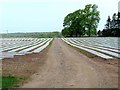
Field at Crofthead
Strips of polythene have been laid across the field to warm the soil. Not sure what crop is anticipated. Beyond, the land drops down to the River Esk.
Image: © Oliver Dixon
Taken: 29 Apr 2011
0.10 miles
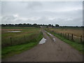
7
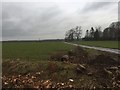
Road to Crofthead
Just south of the Esk.
Image: © Richard Webb
Taken: 13 Feb 2019
0.13 miles
8
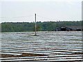
Field at Crofthead
Strips of polythene have been laid across the field to warm the soil. Not sure what crop is anticipated. Beyond, the land drops down to the River Esk.
Image: © Oliver Dixon
Taken: 29 Apr 2011
0.14 miles
9
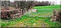
Field gateway at SE edge of Slackbraes Wood
Ordnance Survey records indicate that a benchmark levelled at 24.088m above Newlyn Datum was verified in 1955 on a gatepost at this gateway which appears to have been remodelled since
Image: © Roger Templeman
Taken: 14 Apr 2022
0.17 miles