
IMAGES TAKEN NEAR TO
Netherby Road, CARLISLE, CA6 5NT
Introduction
This page details the photographs taken nearby to Netherby Road, CA6 5NT by members of the Geograph project.
The Geograph project started in 2005 with the aim of publishing, organising and preserving representative images for every square kilometre of Great Britain, Ireland and the Isle of Man.

There are currently over 7.5m images from over14,400 individuals and you can help contribute to the project by visiting https://www.geograph.org.uk
Image Map
Images are licensed for reuse under creativecommons.org/licenses/by-sa/2.0
Notes
- Clicking on the map will re-center to the selected point.
- The higher the marker number, the further away the image location is from the centre of the postcode.
Image Listing (87 Images Found)
Images are licensed for reuse under creativecommons.org/licenses/by-sa/2.0
Image
Details
Distance

2

Benchmark on western parapet of Powdrake Bridge
Ordnance Survey cut mark benchmark levelled at 19.437m above Newlyn Datum verified 1955
Image: © Roger Templeman
Taken: 14 Apr 2022
0.05 miles
3
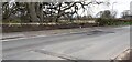
View of western parapet of Powdrake Bridge across Netherby Road
There is an Ordnance Survey benchmark Image on the parapet next to a book placed beside it
Image: © Roger Templeman
Taken: 14 Apr 2022
0.06 miles


6

The River Esk at Longtown
This stretch of the river is north of Longtown Bridge.
Image: © Walter Baxter
Taken: 22 Nov 2011
0.11 miles
7

An informative sign at Longtown
This sign on the east side of the River Esk with missing letters should read – Public footpath Esk Bridge.
Image: © Walter Baxter
Taken: 22 Nov 2011
0.11 miles
8

The River Esk at Longtown
This is a view upstream above Longtown Bridge. A kingfisher flew over the water showing brilliant colours in the low afternoon November sun.
Image: © Walter Baxter
Taken: 22 Nov 2011
0.13 miles
9
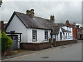
Building beside the Police Station
Dates from pre-1901 and associated with the Police Station.
Image: © John M
Taken: 24 Aug 2017
0.14 miles
10
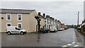
Graham Street
Graham Street is the extension, at an angle, of Netherby Street. It is the way to Netherby, which is the seat of the Graham family.
Image: © Anne Burgess
Taken: 3 Jan 2023
0.14 miles