IMAGES TAKEN NEAR TO
Longtown, CARLISLE, CA6 5NN
Introduction
This page details the photographs taken nearby to CA6 5NN by members of the Geograph project.
The Geograph project started in 2005 with the aim of publishing, organising and preserving representative images for every square kilometre of Great Britain, Ireland and the Isle of Man.

There are currently over 7.5m images from over14,400 individuals and you can help contribute to the project by visiting https://www.geograph.org.uk
Image Map (Loading...)


Getting Data...Please wait
Leaflet Map data © OpenStreetMap
Images are licensed for reuse under creativecommons.org/licenses/by-sa/2.0
Notes
- Clicking on the map will re-center to the selected point.
- The higher the marker number, the further away the image location is from the centre of the postcode.
Image Listing (5 Images Found)
Images are licensed for reuse under creativecommons.org/licenses/by-sa/2.0
Image
Details
Distance
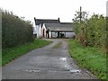
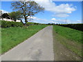
2
Frankstown Farm
A view looking to the south along the access lane to Frankstown Farm.
Image: © Phil Williams
Taken: 13 Feb 2008
0.03 miles
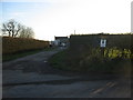
4
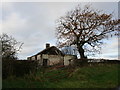
Cubbyhill Cottages
Not fit for habitation!
Image: © Jonathan Thacker
Taken: 24 Nov 2018
0.21 miles
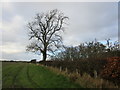
5
Hedge-lined minor road at the derelict Cubbyhill Cottages
Looking northward along this former 'Drove Road'.
Image: © Peter Wood
Taken: 4 May 2019
0.22 miles