IMAGES TAKEN NEAR TO
St. Michaels Drive, CARLISLE, CA6 5FA
Introduction
This page details the photographs taken nearby to St. Michaels Drive, CA6 5FA by members of the Geograph project.
The Geograph project started in 2005 with the aim of publishing, organising and preserving representative images for every square kilometre of Great Britain, Ireland and the Isle of Man.

There are currently over 7.5m images from over14,400 individuals and you can help contribute to the project by visiting https://www.geograph.org.uk
Image Map
Images are licensed for reuse under creativecommons.org/licenses/by-sa/2.0
Notes
- Clicking on the map will re-center to the selected point.
- The higher the marker number, the further away the image location is from the centre of the postcode.
Image Listing (5 Images Found)
Images are licensed for reuse under creativecommons.org/licenses/by-sa/2.0
Image
Details
Distance
1
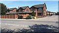
New housing at junction of A7 and Briar Lea Court
Ordnance Survey documents indicate that a benchmark levelled at 20.224m above Newlyn Datum was verified in 1955 on a gatepost at this location
Image: © Roger Templeman
Taken: 1 Jun 2021
0.07 miles

4
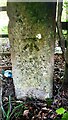
Benchmark on gatepost at gateway in hedge bounding Ladyseat Wood
Ordnance Survey cut mark benchmark levelled at 21.048m above Newlyn Datum in 1971
Image: © Roger Templeman
Taken: 1 Jun 2021
0.22 miles
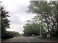
5
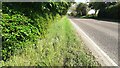
Beech hedge on NE side of A6071 where it passes Ladyseat Wood
There is an Ordnance Survey benchmark Image on a gatepost hidden in the hedge
Image: © Roger Templeman
Taken: 4 Jun 2021
0.25 miles