IMAGES TAKEN NEAR TO
Queens Drive, CARLISLE, CA6 4SB
Introduction
This page details the photographs taken nearby to Queens Drive, CA6 4SB by members of the Geograph project.
The Geograph project started in 2005 with the aim of publishing, organising and preserving representative images for every square kilometre of Great Britain, Ireland and the Isle of Man.

There are currently over 7.5m images from over14,400 individuals and you can help contribute to the project by visiting https://www.geograph.org.uk
Image Map
Images are licensed for reuse under creativecommons.org/licenses/by-sa/2.0
Notes
- Clicking on the map will re-center to the selected point.
- The higher the marker number, the further away the image location is from the centre of the postcode.
Image Listing (7 Images Found)
Images are licensed for reuse under creativecommons.org/licenses/by-sa/2.0
Image
Details
Distance
1
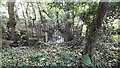
Stream at concrete structure in Kingmoor Nature Reserve
Image: © Luke Shaw
Taken: 26 Sep 2023
0.11 miles
2

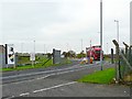
Arrival of our new Pilot
Our new pilot arrived by low loader from Crewe today into Carlisle Warehousing, just a pity it didn't start.
Image: © David Liddle
Taken: 15 Jan 2013
0.13 miles
3

Sunset at Kingmoor Woods
The sun setting over Kingmoor Woods after the snow of January 2010.
Image: © Andy Connor
Taken: 6 Jan 2010
0.18 miles
4
Entrance to Kingmoor Park (Central)
Kingmoor Park is a 400 acre site providing office, warehouse and light industrial accommodation. It was developed on land previously used as an RAF maintenance unit (14MU), which closed in the mid 1990's. It still appears to have good security in place.
Image: © Rose and Trev Clough
Taken: 5 Nov 2008
0.20 miles
5

Kingmoor (South) Nature Reserve
King Edward III owned some moorland in this area which he gave to the city of Carlisle in 1352. The "King's Moor" became common land for grazing and peat cutting, and part of it was used as a racecourse. Over the last 300 years woodland has been planted, and also developed naturally. The woodland became a nature reserve in 1914, and today is managed by Carlisle City Council.
Image: © Rose and Trev Clough
Taken: 5 Nov 2008
0.22 miles
6
Bench and pond, Kingmoor (South) Nature Reserve
Image: © Rose and Trev Clough
Taken: 5 Nov 2008
0.22 miles
7

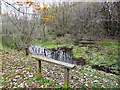
Footbridge, Kingmoor (South) Nature Reserve
Kingmoor is the largest area of woodland in Carlisle, and is managed by the City Council. There are surfaced paths and many benches, making it accessible to people with limited mobility. Once a continuous strip of woodland, Kingmoor Nature Reserve is now segmented by the Kingstown Industrial Estate. See Image
Image: © Rose and Trev Clough
Taken: 5 Nov 2008
0.24 miles