IMAGES TAKEN NEAR TO
The Nurseries, CARLISLE, CA6 4RR
Introduction
This page details the photographs taken nearby to The Nurseries, CA6 4RR by members of the Geograph project.
The Geograph project started in 2005 with the aim of publishing, organising and preserving representative images for every square kilometre of Great Britain, Ireland and the Isle of Man.

There are currently over 7.5m images from over14,400 individuals and you can help contribute to the project by visiting https://www.geograph.org.uk
Image Map (Loading...)


Getting Data...Please wait
Leaflet Map data © OpenStreetMap
Images are licensed for reuse under creativecommons.org/licenses/by-sa/2.0
Notes
- Clicking on the map will re-center to the selected point.
- The higher the marker number, the further away the image location is from the centre of the postcode.
Image Listing (30 Images Found)
Images are licensed for reuse under creativecommons.org/licenses/by-sa/2.0
Image
Details
Distance
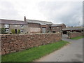
1
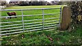
Young ram in field on the SE side of road in Linstock
There is an Ordnance Survey benchmark Image on the inside face of the gatepost at the right hand side of the gateway
Image: © Roger Templeman
Taken: 14 Nov 2022
0.04 miles
2
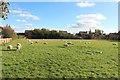
Small field, Linstock
A small, and as yet, undeveloped field in the middle of Linstock. A group of sheep are living in the field.
Image: © Graham Robson
Taken: 6 Oct 2018
0.04 miles
3
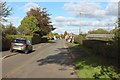
Road through Linstock
One of the village roads in Linstock. The village green or playing field is ahead on the right.
Image: © Graham Robson
Taken: 6 Oct 2018
0.05 miles
6
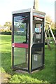
Phone box, Linstock
The public phone box in the middle of Linstock. Image shows the wider context of its location 12 years earlier. The swing partially hidden behind the phone box has been added at some point in the intervening years.
Image: © Graham Robson
Taken: 6 Oct 2018
0.05 miles
7
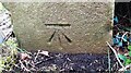
Benchmark on gatepost at field gateway on SE side of road
Ordnance Survey cut mark benchmark levelled at 21.473m above Newlyn Datum verified 1972
Image: © Roger Templeman
Taken: 14 Nov 2022
0.05 miles
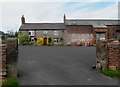
9
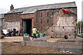
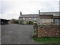
Barn conversion in progress
A photo taken in 2012 Image shows the site before redevelopment, with a byre and cart shed attached to the main barn.
Image: © Rose and Trev Clough
Taken: 19 Aug 2015
0.05 miles
10
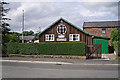
Women's Institute Hall, Linstock
The white plaque says 'This hall was opened by Mrs.Creighton, Mayoress of Carlisle, 22nd February 1922'.
Image: © Rose and Trev Clough
Taken: 19 Aug 2015
0.07 miles