IMAGES TAKEN NEAR TO
Walby, Crosby-on-Eden, CARLISLE, CA6 4QL
Introduction
This page details the photographs taken nearby to CA6 4QL by members of the Geograph project.
The Geograph project started in 2005 with the aim of publishing, organising and preserving representative images for every square kilometre of Great Britain, Ireland and the Isle of Man.

There are currently over 7.5m images from over14,400 individuals and you can help contribute to the project by visiting https://www.geograph.org.uk
Image Map
Images are licensed for reuse under creativecommons.org/licenses/by-sa/2.0
Notes
- Clicking on the map will re-center to the selected point.
- The higher the marker number, the further away the image location is from the centre of the postcode.
Image Listing (8 Images Found)
Images are licensed for reuse under creativecommons.org/licenses/by-sa/2.0
Image
Details
Distance
1
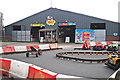
Activities at Walby Farm Park
At Walby Farm Park http://www.walbyfarmpark.co.uk/ children can learn about animals and farming, and keep busy on the numerous activities. This is a view over the fence to the mini quad track and animal barn.
The farm park was opened in 2008 by the owners of Walby Grange Farm, it occupies 30 acres of their 430 acre farm estate.
Image: © Rose and Trev Clough
Taken: 17 Jul 2016
0.03 miles
2
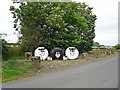
Who ewe looking at?
Novelty sheep near the entrance to the popular attraction of Walby Farm Park http://www.walbyfarmpark.co.uk/ .
Image: © Rose and Trev Clough
Taken: 17 Jul 2016
0.05 miles
3
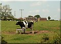
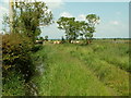
View of Walby across field of cows
Image: © Rose and Trev Clough
Taken: 8 Jun 2007
0.08 miles
5

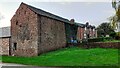
Barn and slurry tank at farm on west side of Birky Lane
Image: © Luke Shaw
Taken: 14 Nov 2022
0.15 miles
7
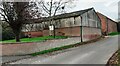
Buildings at Ellengrove Walby Farm on west side of Birky Lane
Image: © Roger Templeman
Taken: 14 Nov 2022
0.17 miles
8
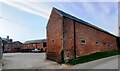
Farm buildings on west side of Birky Lane
Ordnance Survey documents indicate that a benchmark levelled at 22.029m above Newlyn Datum was verified in 1972 on the road face of the barn 4.5m from the near angle
Image: © Roger Templeman
Taken: 14 Nov 2022
0.17 miles