IMAGES TAKEN NEAR TO
Oak Drive, CARLISLE, CA6 4PD
Introduction
This page details the photographs taken nearby to Oak Drive, CA6 4PD by members of the Geograph project.
The Geograph project started in 2005 with the aim of publishing, organising and preserving representative images for every square kilometre of Great Britain, Ireland and the Isle of Man.

There are currently over 7.5m images from over14,400 individuals and you can help contribute to the project by visiting https://www.geograph.org.uk
Image Map
Images are licensed for reuse under creativecommons.org/licenses/by-sa/2.0
Notes
- Clicking on the map will re-center to the selected point.
- The higher the marker number, the further away the image location is from the centre of the postcode.
Image Listing (12 Images Found)
Images are licensed for reuse under creativecommons.org/licenses/by-sa/2.0
Image
Details
Distance
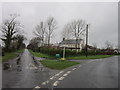
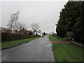
2
Road Junction at Newtown on Hadrian's Wall Path
Image: © Anthony Parkes
Taken: 5 Aug 2014
0.04 miles
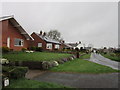
3
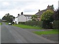
Houses at Newtown
A particularly well-kept village which lies on Hadrian's Wall National Trail which runs 84 miles from Bowness-on-Solway to Wallsend.
http://www.nationaltrail.co.uk/hadrianswall/
Image: © Oliver Dixon
Taken: 24 Sep 2008
0.06 miles
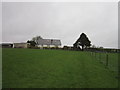

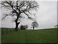
9
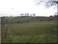
View near Irthington
Taken from the footpath to Newtown.
Image: © Jonathan Thacker
Taken: 25 Nov 2010
0.23 miles