IMAGES TAKEN NEAR TO
Irthington, CARLISLE, CA6 4NS
Introduction
This page details the photographs taken nearby to CA6 4NS by members of the Geograph project.
The Geograph project started in 2005 with the aim of publishing, organising and preserving representative images for every square kilometre of Great Britain, Ireland and the Isle of Man.

There are currently over 7.5m images from over14,400 individuals and you can help contribute to the project by visiting https://www.geograph.org.uk
Image Map
Images are licensed for reuse under creativecommons.org/licenses/by-sa/2.0
Notes
- Clicking on the map will re-center to the selected point.
- The higher the marker number, the further away the image location is from the centre of the postcode.
Image Listing (19 Images Found)
Images are licensed for reuse under creativecommons.org/licenses/by-sa/2.0
Image
Details
Distance
1
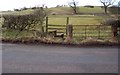
Footpath to Newtown.
Opposite the Motte which is not very photogenic but have a look in this square at the other picture anyway.
Image: © John Holmes
Taken: 25 Feb 2006
0.02 miles
2
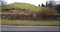
Motte.
See the photo of the footpath opposite for a better view of this square.
Image: © John Holmes
Taken: 25 Feb 2006
0.02 miles
4
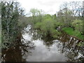
The Cam Beck
Looking downstream from Cambeck Bridge.
Image: © M J Richardson
Taken: 26 Apr 2022
0.12 miles
5
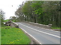
Cambeck Bridge
The bridge carries the A6071, Longtown to Brampton road, across the Cam Beck, a tributary of the River Irthing which it joins close to this point.
Image: © G Laird
Taken: 26 Apr 2017
0.17 miles
6
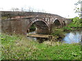
Cambeck Bridge
A Grade II listed structure carrying the A6071 over the Cam Beck https://historicengland.org.uk/listing/the-list/list-entry/1335527.
Image: © M J Richardson
Taken: 26 Apr 2022
0.17 miles
7
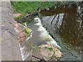
Small weir on the Cam Beck
Just upstream from Cambeck Bridge, on which Dandelions were growing.
Image: © M J Richardson
Taken: 26 Apr 2022
0.17 miles
8
Cambeck Bridge taking A6071 over Cam Beck
There is an Ordnance Survey benchmark Image on top of the left hand parapet over the centre of the river
Image: © Roger Templeman
Taken: 4 Mar 2023
0.17 miles
9
Benchmark on top of north parapet of Cambeck Bridge
Ordnance Survey rivet benchmark levelled at 36.612m above Newlyn Datum in 1971 and verified in 1972
Image: © Roger Templeman
Taken: 4 Mar 2023
0.18 miles
10
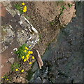
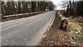
Dandelions on Cambeck Bridge
Looking vertically down onto the top of the northernmost pier.
Image: © M J Richardson
Taken: 26 Apr 2022
0.18 miles