
IMAGES TAKEN NEAR TO
Scaleby, CARLISLE, CA6 4LS
Introduction
This page details the photographs taken nearby to CA6 4LS by members of the Geograph project.
The Geograph project started in 2005 with the aim of publishing, organising and preserving representative images for every square kilometre of Great Britain, Ireland and the Isle of Man.

There are currently over 7.5m images from over14,400 individuals and you can help contribute to the project by visiting https://www.geograph.org.uk
Image Map
Images are licensed for reuse under creativecommons.org/licenses/by-sa/2.0
Notes
- Clicking on the map will re-center to the selected point.
- The higher the marker number, the further away the image location is from the centre of the postcode.
Image Listing (5 Images Found)
Images are licensed for reuse under creativecommons.org/licenses/by-sa/2.0
Image
Details
Distance
1
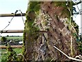
Benchmark, Stoneknowe
Detail of the Ordnance Survey cut banchmark on a red sandstone gatepost near Stoneknowe. The benchmark marks a height of 31.2151m above sea level (Ordnance Datum Newlyn) last verified in 1974.
Image: © Adrian Taylor
Taken: 30 Jan 2021
0.10 miles
2
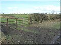
Muddy gateway
The old metal field gate is held in place by a piece of twine tied round a roughly hewn red sandstone gatepost. There is an Ordnance Survey cut benchmark near the bottom of the gatepost.
Image: © Adrian Taylor
Taken: 30 Jan 2021
0.10 miles
3
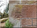
Ordnance Survey benchmark, Barclose Farm House
The Ordnance Survey benchmark cut into the sandstone quoin of Barclose Farm House marks a height of 33.5061m above sea level (Ordnance Datum Newlyn) last verified in 1975 (location photograph Image).
Image: © Adrian Taylor
Taken: 27 Mar 2020
0.22 miles
4

Ordnance Survey Benchmark, Barclose
Detail of the east corner of Barclose Farm House. There is an Ordnance Survey cut benchmark on one of the stone quoins (photograph Image).
Image: © Adrian Taylor
Taken: 27 Mar 2020
0.22 miles
5
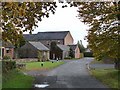
Barclose
Small cluster of houses near Scaleby.
Image: © Oliver Dixon
Taken: 3 Nov 2010
0.22 miles