IMAGES TAKEN NEAR TO
Scaleby Hill, CARLISLE, CA6 4LF
Introduction
This page details the photographs taken nearby to CA6 4LF by members of the Geograph project.
The Geograph project started in 2005 with the aim of publishing, organising and preserving representative images for every square kilometre of Great Britain, Ireland and the Isle of Man.

There are currently over 7.5m images from over14,400 individuals and you can help contribute to the project by visiting https://www.geograph.org.uk
Image Map
Images are licensed for reuse under creativecommons.org/licenses/by-sa/2.0
Notes
- Clicking on the map will re-center to the selected point.
- The higher the marker number, the further away the image location is from the centre of the postcode.
Image Listing (4 Images Found)
Images are licensed for reuse under creativecommons.org/licenses/by-sa/2.0
Image
Details
Distance
1
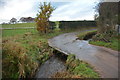
Scaleby Mill Ford
This irish bridge ford is found on the Highberries Beck at Scaleby Mill.
Image: © John Walton
Taken: 19 Nov 2016
0.22 miles
2
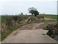
Bridleway from Scaleby Mill to Laversdale
After crossing Highberries Beck the bridleway goes straight ahead. The more solid track to the right leads to a house.
Image: © Rose and Trev Clough
Taken: 17 Feb 2008
0.23 miles
3
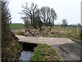
Bridge across Highberries Beck
The Explorer map indicates a ford and footbridge here, which have evidently been replaced by the concrete structure - more practical but probably less picturesque.
Image: © Rose and Trev Clough
Taken: 17 Feb 2008
0.23 miles
4
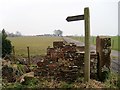
Signpost at entrance to Woodhead Farm
A public footpath branches here : straight ahead to Woodhead, turn left for Laversdale.
Image: © Rose and Trev Clough
Taken: 17 Feb 2008
0.24 miles