IMAGES TAKEN NEAR TO
High Knells, Houghton, CARLISLE, CA6 4JW
Introduction
This page details the photographs taken nearby to CA6 4JW by members of the Geograph project.
The Geograph project started in 2005 with the aim of publishing, organising and preserving representative images for every square kilometre of Great Britain, Ireland and the Isle of Man.

There are currently over 7.5m images from over14,400 individuals and you can help contribute to the project by visiting https://www.geograph.org.uk
Image Map
Images are licensed for reuse under creativecommons.org/licenses/by-sa/2.0
Notes
- Clicking on the map will re-center to the selected point.
- The higher the marker number, the further away the image location is from the centre of the postcode.
Image Listing (6 Images Found)
Images are licensed for reuse under creativecommons.org/licenses/by-sa/2.0
Image
Details
Distance
1
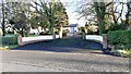
Entrance to Highfield Grange
There is an Ordnance Survey benchmark Image on the right hand brick pier
Image: © Roger Templeman
Taken: 19 Jan 2022
0.01 miles
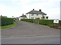
3

Benchmark on brick pier at entrance to Highfield Grange
Ordnance Survey cut mark benchmark levelled at 33.522m above Newlyn Datum verified 1972
Image: © Roger Templeman
Taken: 19 Jan 2022
0.03 miles
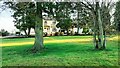
5
Green Acres Farm
And entrance to Caravan Park
Image: © Oliver Dixon
Taken: 24 Sep 2006
0.11 miles
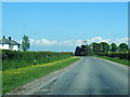
6

Dykeside on NW side of rural road at track junction
Image: © Luke Shaw
Taken: 19 Jan 2022
0.15 miles