IMAGES TAKEN NEAR TO
Harker Road Ends, CARLISLE, CA6 4HL
Introduction
This page details the photographs taken nearby to CA6 4HL by members of the Geograph project.
The Geograph project started in 2005 with the aim of publishing, organising and preserving representative images for every square kilometre of Great Britain, Ireland and the Isle of Man.

There are currently over 7.5m images from over14,400 individuals and you can help contribute to the project by visiting https://www.geograph.org.uk
Image Map
Images are licensed for reuse under creativecommons.org/licenses/by-sa/2.0
Notes
- Clicking on the map will re-center to the selected point.
- The higher the marker number, the further away the image location is from the centre of the postcode.
Image Listing (5 Images Found)
Images are licensed for reuse under creativecommons.org/licenses/by-sa/2.0
Image
Details
Distance
2
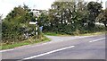
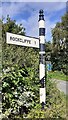
Crossroads at Harker
There is a Cumberland County Council signpost Image at the junction
Image: © Roger Templeman
Taken: 17 Aug 2021
0.07 miles
3
Cumberland County Council signpost east of Rockcliffe
The signpost has Milestone Society National ID: CU_NY3761
Image: © Roger Templeman
Taken: 17 Aug 2021
0.07 miles