IMAGES TAKEN NEAR TO
Blackford, CARLISLE, CA6 4EQ
Introduction
This page details the photographs taken nearby to CA6 4EQ by members of the Geograph project.
The Geograph project started in 2005 with the aim of publishing, organising and preserving representative images for every square kilometre of Great Britain, Ireland and the Isle of Man.

There are currently over 7.5m images from over14,400 individuals and you can help contribute to the project by visiting https://www.geograph.org.uk
Image Map
Images are licensed for reuse under creativecommons.org/licenses/by-sa/2.0
Notes
- Clicking on the map will re-center to the selected point.
- The higher the marker number, the further away the image location is from the centre of the postcode.
Image Listing (13 Images Found)
Images are licensed for reuse under creativecommons.org/licenses/by-sa/2.0
Image
Details
Distance
1
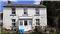
Riggmoor House
There is an Ordnance Survey benchmark Image on the right hand side of the house at its front corner
Image: © Roger Templeman
Taken: 11 May 2021
0.00 miles
2
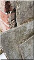
Benchmark on Riggmoor House
Ordnance Survey cut mark benchmark levelled at 25.097m above Newlyn Datum verified 1972 partly hidden by stacked building materials
Image: © Roger Templeman
Taken: 11 May 2021
0.01 miles
3
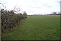
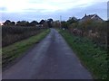
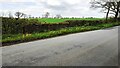
Field near Westlinton
The low lying ground around the Solway Firth is usually used for grazing.
Image: © Richard Webb
Taken: 4 Apr 2019
0.09 miles
5
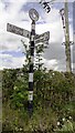
Cumberland County Council finger signpost at Dike Nook
The right hand finger indicates Alstonby 1¾ and Cliff 2¼
The signpost has Milestone Society National ID: CU_NY4063
Image: © Roger Templeman
Taken: 11 May 2021
0.16 miles
6
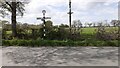
Road junction at Dyke Nook
There is a close up photo of the Cumberland County Council signpost at Image
Image: © Roger Templeman
Taken: 11 May 2021
0.18 miles
8
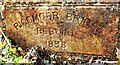
Name and date stone set into NW parapet of Riggmoor Bridge
There is a wider view of the parapet at Image
The stone has Milestone Society National ID CU_WLINT01br
Image: © Roger Templeman
Taken: 11 May 2021
0.19 miles
9
NW parapet of Riggmoor Bridge
There is an Ordnance Survey benchmark Image on a stone at the base of the parapet about 1 foot from its left hand end
Image: © Roger Templeman
Taken: 11 May 2021
0.20 miles
10
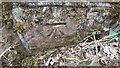
Benchmark on Riggmoor Bridge
Ordnance Survey cut mark benchmark levelled at 23.239m above Newlyn Datum verified in 1972
Image: © Roger Templeman
Taken: 11 May 2021
0.20 miles