IMAGES TAKEN NEAR TO
Blackford, CARLISLE, CA6 4EN
Introduction
This page details the photographs taken nearby to CA6 4EN by members of the Geograph project.
The Geograph project started in 2005 with the aim of publishing, organising and preserving representative images for every square kilometre of Great Britain, Ireland and the Isle of Man.

There are currently over 7.5m images from over14,400 individuals and you can help contribute to the project by visiting https://www.geograph.org.uk
Image Map
Images are licensed for reuse under creativecommons.org/licenses/by-sa/2.0
Notes
- Clicking on the map will re-center to the selected point.
- The higher the marker number, the further away the image location is from the centre of the postcode.
Image Listing (8 Images Found)
Images are licensed for reuse under creativecommons.org/licenses/by-sa/2.0
Image
Details
Distance
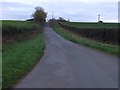
6
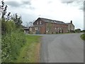
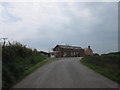
Howberry
Country lane and the houses at Howberry
Image: © Adrian Taylor
Taken: 31 Oct 2006
0.10 miles
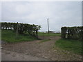
7
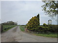
Driveway to the Gill Farm
The blacked out lettering on the sign indicates that this farm also ran a bed-and-breakfast business at one time. I stayed there in 1993 when surveying for the Reivers Cycle Route which passes along the road in the foreground..
Image: © Oliver Dixon
Taken: 10 May 2019
0.17 miles