IMAGES TAKEN NEAR TO
Houghton, CARLISLE, CA6 4DX
Introduction
This page details the photographs taken nearby to CA6 4DX by members of the Geograph project.
The Geograph project started in 2005 with the aim of publishing, organising and preserving representative images for every square kilometre of Great Britain, Ireland and the Isle of Man.

There are currently over 7.5m images from over14,400 individuals and you can help contribute to the project by visiting https://www.geograph.org.uk
Image Map
Images are licensed for reuse under creativecommons.org/licenses/by-sa/2.0
Notes
- Clicking on the map will re-center to the selected point.
- The higher the marker number, the further away the image location is from the centre of the postcode.
Image Listing (5 Images Found)
Images are licensed for reuse under creativecommons.org/licenses/by-sa/2.0
Image
Details
Distance
1
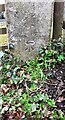
Benchmark on gatepost at field gateway on west side of road opposite West Lodge
Ordnance Survey cut mark benchmark levelled at 29.871m above Newlyn Datum and verified in 1972
Image: © Luke Shaw
Taken: 16 Apr 2021
0.17 miles
2
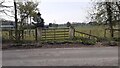
Field gateway on west side of road north of The Pleasants
There is an Ordnance Survey benchmark Image on the road face of the right hand gatepost of the gateway
Image: © Luke Shaw
Taken: 16 Apr 2021
0.20 miles
3
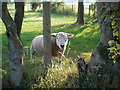
Inquisitive Sheep at Crosshill near Houghton
Image: © Keith Fairhurst
Taken: 4 Jul 2006
0.21 miles
4
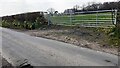
Field gateway on west side of rural road east of Houghton House Plantation
The verge has many daffodils providing signs of spring
Image: © Roger Templeman
Taken: 16 Apr 2021
0.23 miles
5
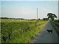
Road to Crosshill Village from Houghton
This is a regular walk for Ben (The Border Collie in shot) and I.
Image: © Keith Fairhurst
Taken: 4 Jul 2006
0.25 miles