IMAGES TAKEN NEAR TO
Rockcliffe, CARLISLE, CA6 4AA
Introduction
This page details the photographs taken nearby to CA6 4AA by members of the Geograph project.
The Geograph project started in 2005 with the aim of publishing, organising and preserving representative images for every square kilometre of Great Britain, Ireland and the Isle of Man.

There are currently over 7.5m images from over14,400 individuals and you can help contribute to the project by visiting https://www.geograph.org.uk
Image Map
Images are licensed for reuse under creativecommons.org/licenses/by-sa/2.0
Notes
- Clicking on the map will re-center to the selected point.
- The higher the marker number, the further away the image location is from the centre of the postcode.
Image Listing (48 Images Found)
Images are licensed for reuse under creativecommons.org/licenses/by-sa/2.0
Image
Details
Distance
1
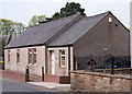
Former "Mounsey Arms", Rockcliffe - April 2017 (2)
For information on this building, see: Image] .
Image: © The Carlisle Kid
Taken: 30 Apr 2017
0.04 miles
2
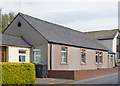
Former "Mounsey Arms", Rockcliffe - April 2017 (1)
In 1916, the village of Rockcliffe had two pubs - the Ship Inn (see: Image] ) and the Crown & Thistle (see: Image] ) These were acquired by the State Management Scheme in October 1916 and promptly closed - with the Ship later sold as a private dwelling. Pub business was transferred to the local village hall, which was refurbished by the Scheme and opened on 24 August 1917 as the Mounsey Arms on a 7 year lease. Records then become vague, but it is certain the Mounsey Arms was not part of the State disposals in 1973, while a 1973 OS map shows the Crown & Thistle as reopened. In any event, the Mounsey Arms is now a private dwelling - appropriately named the Mounsey Arms Cottage.
Image: © The Carlisle Kid
Taken: 30 Apr 2017
0.04 miles
3
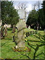
The Parish Church of St Mary the Virgin, Rockcliffe and Cargo, Stone cross
Image: © Alexander P Kapp
Taken: 24 Apr 2008
0.04 miles
4

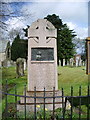
Rockcliffe War Memorial - April 2017
Situated in the grounds of the Parish Church of St Mary the Virgin, the memorial is difficult to photograph as it is positioned very close to the Church railings. Alexander P Kapp was possibly more successful when he visited in 2008 - see: Image] .
Image: © The Carlisle Kid
Taken: 30 Apr 2017
0.05 miles
5

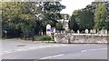
Direction Sign ? Signpost
Located on the southwest side of a T junction at Rockcliffe church in Rockcliffe parish. 2 arms and annulus finial.
Milestone Society National ID: CU_NY3561
Image: © J Glew
Taken: 1 May 2019
0.05 miles
6
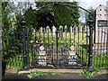
Two access methods into St Mary's Church churchyard
Either through the metal gates or using stone steps
Image: © Luke Shaw
Taken: 17 Aug 2021
0.05 miles


9
The Parish Church of St Mary the Virgin, Rockcliffe and Cargo, War Memorial
Image: © Alexander P Kapp
Taken: 24 Apr 2008
0.05 miles
10
The Parish Church of St Mary the Virgin, Rockcliffe and Cargo, Gate
Image: © Alexander P Kapp
Taken: 24 Apr 2008
0.05 miles