IMAGES TAKEN NEAR TO
Riverside, CARLISLE, CA5 7QG
Introduction
This page details the photographs taken nearby to Riverside, CA5 7QG by members of the Geograph project.
The Geograph project started in 2005 with the aim of publishing, organising and preserving representative images for every square kilometre of Great Britain, Ireland and the Isle of Man.

There are currently over 7.5m images from over14,400 individuals and you can help contribute to the project by visiting https://www.geograph.org.uk
Image Map (Loading...)


Getting Data...Please wait
Leaflet Map data © OpenStreetMap
Images are licensed for reuse under creativecommons.org/licenses/by-sa/2.0
Notes
- Clicking on the map will re-center to the selected point.
- The higher the marker number, the further away the image location is from the centre of the postcode.
Image Listing (36 Images Found)
Images are licensed for reuse under creativecommons.org/licenses/by-sa/2.0
Image
Details
Distance
2
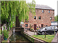
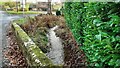
Converted corn mill
There was a mill here from medieval times, called Bishop's Mill because it belonged to the Bishop of Carlisle (who was also Lord of the Manor). During the 20th century the site was occupied by a joinery business. This building was converted into two houses in the early 2000s.
The mill race is on the left.
Image: © Rose and Trev Clough
Taken: 25 May 2016
0.05 miles
3
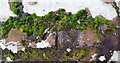
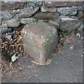
Benchmark on south parapet of bridge over mill race
Ordnance Survey rivet benchmark levelled at 47.808m above Newlyn Datum verified 1970
Image: © Roger Templeman
Taken: 25 Nov 2021
0.06 miles
5
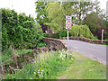
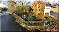
Parapet of bridge over mill race on south side of road
There is an Ordnance Survey benchmark Image on top of the parapet over the centre of the race
Image: © Roger Templeman
Taken: 25 Nov 2021
0.07 miles
7
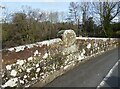
Old Boundary Marker
Bridge Marker on the west side of the B5299, south of Dalston Bridge, River Caldew.
Milestone Society National ID: CU_DALS02br
Image: © Roger Templeman
Taken: 9 Aug 2019
0.08 miles
8
Inscription stone, Union Bridge
This bridge over the River Caldew, named on Ordnance Survey maps as Dalston Bridge, is Grade II listed and features large oval inscription stones on the red sandstone parapets. The north paarapet is shown in the photograph; the very weathered inscription reads UNION BRIDGE.
There is an Ordnance Survey cut benchmark below the inscription stone (photograph Image).
Image: © Adrian Taylor
Taken: 21 Feb 2021
0.08 miles
9
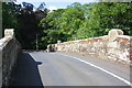
Dalston Bridge over River Caldew
There is an Ordnance Survey benchmark Image on the right hand parapet of the bridge below the cylindrical stone on its top.
Image: © Roger Templeman
Taken: 8 Aug 2019
0.08 miles
10
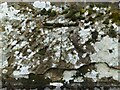
Benchmark, Union Bridge
Detail of the Ordnance Survey cut benchmark on the north parapet of Union Bridge (named Dalston Bridge on Ordnance Survey maps). The benchmark marks a height of 50.917m above sea level (Ordnance Datum Newlyn) last verified in 1969 (location photograph Image).
Image: © Adrian Taylor
Taken: 21 Feb 2021
0.08 miles