IMAGES TAKEN NEAR TO
The Green, CARLISLE, CA5 7QD
Introduction
This page details the photographs taken nearby to The Green, CA5 7QD by members of the Geograph project.
The Geograph project started in 2005 with the aim of publishing, organising and preserving representative images for every square kilometre of Great Britain, Ireland and the Isle of Man.

There are currently over 7.5m images from over14,400 individuals and you can help contribute to the project by visiting https://www.geograph.org.uk
Image Map (Loading...)


Getting Data...Please wait
Leaflet Map data © OpenStreetMap
Images are licensed for reuse under creativecommons.org/licenses/by-sa/2.0
Notes
- Clicking on the map will re-center to the selected point.
- The higher the marker number, the further away the image location is from the centre of the postcode.
Image Listing (25 Images Found)
Images are licensed for reuse under creativecommons.org/licenses/by-sa/2.0
Image
Details
Distance
1
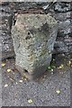
Old Boundary Marker
Bridge Marker on the west side of the B5299, north of Dalston Bridge, River Caldew.
Milestone Society National ID: CU_DALS03br
Image: © Roger Templeman
Taken: 9 Aug 2019
0.08 miles
2
Buckabank Bridge
Road bridge over the River Caldew at Buckabank
Image: © Alexander P Kapp
Taken: 17 May 2006
0.14 miles
3
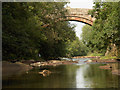
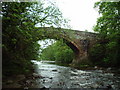
River Caldew
The high bridge carries the road between Buckabank and Green Head.
Image: © Andrew Smith
Taken: 26 Jul 2006
0.14 miles
4
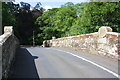
Dalston Bridge over River Caldew
There is an Ordnance Survey benchmark Image on the right hand parapet of the bridge below the cylindrical stone on its top.
Image: © Roger Templeman
Taken: 8 Aug 2019
0.14 miles
5
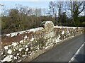
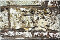
Inscription stone, Union Bridge
This bridge over the River Caldew, named on Ordnance Survey maps as Dalston Bridge, is Grade II listed and features large oval inscription stones on the red sandstone parapets. The north paarapet is shown in the photograph; the very weathered inscription reads UNION BRIDGE.
There is an Ordnance Survey cut benchmark below the inscription stone (photograph Image).
Image: © Adrian Taylor
Taken: 21 Feb 2021
0.14 miles
6
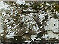
Benchmark, Union Bridge
Detail of the Ordnance Survey cut benchmark on the north parapet of Union Bridge (named Dalston Bridge on Ordnance Survey maps). The benchmark marks a height of 50.917m above sea level (Ordnance Datum Newlyn) last verified in 1969 (location photograph Image).
Image: © Adrian Taylor
Taken: 21 Feb 2021
0.14 miles
7
Benchmark on north parapet of Dalston Bridge
Ordnance Survey cut mark benchmark described on the Bench Mark Database at www.bench-marks.org.uk/bm112300
Image: © Luke Shaw
Taken: 8 Aug 2019
0.14 miles
8
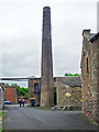
Ellers Mill chimney
A cotton mill was established here in the late 18th century, though some of the original buildings were destroyed by fire in 1901. The firm of Cowens acquired the mill in 1821, and continues in business on the site today. They make cotton wool, felts, wadding etc, diversifying in recent years with a range of environmental products and services (Cowens website http://www.cowens.co.uk/ ).
Image: © Rose and Trev Clough
Taken: 25 May 2016
0.17 miles