IMAGES TAKEN NEAR TO
Carlisle Road, CARLISLE, CA5 7NG
Introduction
This page details the photographs taken nearby to Carlisle Road, CA5 7NG by members of the Geograph project.
The Geograph project started in 2005 with the aim of publishing, organising and preserving representative images for every square kilometre of Great Britain, Ireland and the Isle of Man.

There are currently over 7.5m images from over14,400 individuals and you can help contribute to the project by visiting https://www.geograph.org.uk
Image Map
Images are licensed for reuse under creativecommons.org/licenses/by-sa/2.0
Notes
- Clicking on the map will re-center to the selected point.
- The higher the marker number, the further away the image location is from the centre of the postcode.
Image Listing (35 Images Found)
Images are licensed for reuse under creativecommons.org/licenses/by-sa/2.0
Image
Details
Distance
3
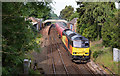
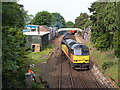
60026 at Dalston - May 2017 (2)
Running about two hours late, Colas Rail liveried 60026 heads out of Dalston station with train 6C34, the 06.22 empty oil tanks from Dalston oil terminal to Carlisle North Yard. Usually, the locomotive returns to Dalson for a second rake of oil wagons, which will be combined in Carlisle to form train 6S36 to Grangemouth Ineos.
See also: Image] .
Image: © The Carlisle Kid
Taken: 31 May 2017
0.07 miles
4
60026 at Dalston - May 2017 (1)
Having collected empty oil wagons from the Dalston oil terminal, Colas Rail liveried diesel locomotive 60026 runs-round its train in Dalston station.
See also: Image] .
Image: © The Carlisle Kid
Taken: 31 May 2017
0.07 miles
6
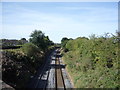
Railway towards Workington
Looking south west from the bridge on Carlisle Road, Dalston.
Image: © JThomas
Taken: 17 Sep 2016
0.08 miles
8
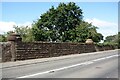
Railway bridge parapet on NW side of B5299 (Carlisle Road)
There is an Ordnance Survey benchmark Image on the parapet wall right of the far parapet pier
Image: © Luke Shaw
Taken: 8 Aug 2019
0.10 miles
9
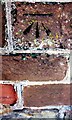
Benchmark on NW parapet of Carlisle Road railway bridge
Ordnance Survey cut mark benchmark described on the Bench Mark Database at www.bench-marks.org.uk/bm112303
Image: © Luke Shaw
Taken: 8 Aug 2019
0.10 miles