IMAGES TAKEN NEAR TO
Durdar, CARLISLE, CA5 7LJ
Introduction
This page details the photographs taken nearby to CA5 7LJ by members of the Geograph project.
The Geograph project started in 2005 with the aim of publishing, organising and preserving representative images for every square kilometre of Great Britain, Ireland and the Isle of Man.

There are currently over 7.5m images from over14,400 individuals and you can help contribute to the project by visiting https://www.geograph.org.uk
Image Map
Images are licensed for reuse under creativecommons.org/licenses/by-sa/2.0
Notes
- Clicking on the map will re-center to the selected point.
- The higher the marker number, the further away the image location is from the centre of the postcode.
Image Listing (11 Images Found)
Images are licensed for reuse under creativecommons.org/licenses/by-sa/2.0
Image
Details
Distance
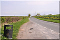
1
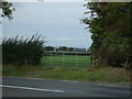
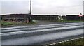
Minor road towards Durdar
Heading north east.
Image: © JThomas
Taken: 10 Oct 2015
0.12 miles
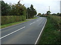
6
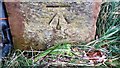
Benchmark on gatepost on NW side of road at farm lane junction
Ordnance Survey cut mark benchmark levelled at 65.657m above Newlyn Datum verified 1969
Image: © Roger Templeman
Taken: 15 Dec 2021
0.18 miles
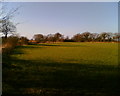
7
Junction of rural road with lane to Park Fauld Farm
There is an Ordnance Survey benchmark Image on the inside face of the gatepost at the right hand side of the field gate
Image: © Roger Templeman
Taken: 15 Dec 2021
0.18 miles