IMAGES TAKEN NEAR TO
Welton, CARLISLE, CA5 7HW
Introduction
This page details the photographs taken nearby to CA5 7HW by members of the Geograph project.
The Geograph project started in 2005 with the aim of publishing, organising and preserving representative images for every square kilometre of Great Britain, Ireland and the Isle of Man.

There are currently over 7.5m images from over14,400 individuals and you can help contribute to the project by visiting https://www.geograph.org.uk
Image Map (Loading...)


Getting Data...Please wait
Leaflet Map data © OpenStreetMap
Images are licensed for reuse under creativecommons.org/licenses/by-sa/2.0
Notes
- Clicking on the map will re-center to the selected point.
- The higher the marker number, the further away the image location is from the centre of the postcode.
Image Listing (4 Images Found)
Images are licensed for reuse under creativecommons.org/licenses/by-sa/2.0
Image
Details
Distance
1
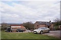
Buildings at Waterside
The gold car is my 2007 Jaguar XK. The larger building beyond is a private dwelling, probably converted from a former barn. Behind the photographer is a farmhouse named Waterside. See also: Image
Image: © Richard Dorrell
Taken: 13 Apr 2019
0.11 miles
2
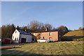
Waterside, Warnell
Hillside farmhouse to the west of Sebergham.
Image: © Richard Dorrell
Taken: 13 Apr 2019
0.12 miles
3
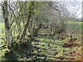
Footpath towards Lonningfoot
An old green lane.
We decided not to "plodge" through the mud.
Image: © Les Hull
Taken: 25 Mar 2012
0.19 miles