IMAGES TAKEN NEAR TO
Welton, CARLISLE, CA5 7HJ
Introduction
This page details the photographs taken nearby to CA5 7HJ by members of the Geograph project.
The Geograph project started in 2005 with the aim of publishing, organising and preserving representative images for every square kilometre of Great Britain, Ireland and the Isle of Man.

There are currently over 7.5m images from over14,400 individuals and you can help contribute to the project by visiting https://www.geograph.org.uk
Image Map (Loading...)


Getting Data...Please wait
Leaflet Map data © OpenStreetMap
Images are licensed for reuse under creativecommons.org/licenses/by-sa/2.0
Notes
- Clicking on the map will re-center to the selected point.
- The higher the marker number, the further away the image location is from the centre of the postcode.
Image Listing (3 Images Found)
Images are licensed for reuse under creativecommons.org/licenses/by-sa/2.0
Image
Details
Distance
2
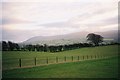
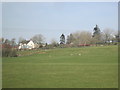
Looking south from Rylands
Knott, High Pike and Carrock Fell rise across the valley.
Image: © Andrew Smith
Taken: 19 Dec 2005
0.05 miles
3
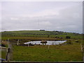
Small Pond
Situated behind a bungalow, with the omnipresent Hill Top transmitter in distance.
Image: © Bob Jenkins
Taken: 27 Jan 2006
0.18 miles