IMAGES TAKEN NEAR TO
Welton, CARLISLE, CA5 7HA
Introduction
This page details the photographs taken nearby to CA5 7HA by members of the Geograph project.
The Geograph project started in 2005 with the aim of publishing, organising and preserving representative images for every square kilometre of Great Britain, Ireland and the Isle of Man.

There are currently over 7.5m images from over14,400 individuals and you can help contribute to the project by visiting https://www.geograph.org.uk
Image Map (Loading...)


Getting Data...Please wait
Leaflet Map data © OpenStreetMap
Images are licensed for reuse under creativecommons.org/licenses/by-sa/2.0
Notes
- Clicking on the map will re-center to the selected point.
- The higher the marker number, the further away the image location is from the centre of the postcode.
Image Listing (10 Images Found)
Images are licensed for reuse under creativecommons.org/licenses/by-sa/2.0
Image
Details
Distance
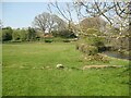
1
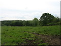
Field near Lanehead Farm
Looking down towards the River Caldew.
Image: © David Purchase
Taken: 7 Jun 2019
0.07 miles
2
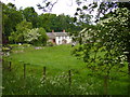
Old mill below Bell Bridge
From where Cumbria Way crosses abandoned mill leat
Image: © Tony Vickers
Taken: 24 May 2008
0.09 miles
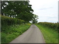
3
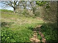
Footpath near Crookholme Mill
The public footpath from Bell Bridge to Rose Bridge is the route of The Cumbria Way long distance path (next photograph Image).
Image: © Adrian Taylor
Taken: 20 Apr 2019
0.12 miles
4
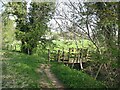
Footbridge near Crookholme Mill
The public footpath from Bell Bridge to Rose Bridge crosses this footbridge over the disused headrace of Crookholme Mill.
The footpath is the route of The Cumbria Way (next photograph Image).
Image: © Adrian Taylor
Taken: 20 Apr 2019
0.13 miles
6
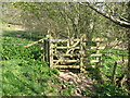
Gate and footbridge
The gate and footbridge over a small stream are on the public footpath from Bell Bridge to Rose Bridge; this is also the route of The Cumbria Way (next photograph Image).
Image: © Adrian Taylor
Taken: 20 Apr 2019
0.14 miles
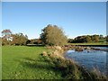
7
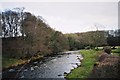
The Cumbria Way near Bellbridge
The Cumbria Way long distance path from Ulverston to Carlisle follows the bank of the River Caldew near Bellbridge (next photograph Image).
Image: © Adrian Taylor
Taken: 20 Apr 2019
0.14 miles
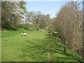
9
The Cumbria Way near Bellbridge
The Cumbria Way follows the public footpath from Bell Bridge to Rose Bridge beside the River Caldew.
Image: © Adrian Taylor
Taken: 20 Apr 2019
0.19 miles
10
The River Caldew near Crookholme Mill
The Cumbria Way long distance path follows a public footpath along the riverbank to Rose bridge (next photograph Image).
Image: © Adrian Taylor
Taken: 10 Nov 2013
0.20 miles