IMAGES TAKEN NEAR TO
Sebergham, CARLISLE, CA5 7DQ
Introduction
This page details the photographs taken nearby to CA5 7DQ by members of the Geograph project.
The Geograph project started in 2005 with the aim of publishing, organising and preserving representative images for every square kilometre of Great Britain, Ireland and the Isle of Man.

There are currently over 7.5m images from over14,400 individuals and you can help contribute to the project by visiting https://www.geograph.org.uk
Image Map (Loading...)


Getting Data...Please wait
Leaflet Map data © OpenStreetMap
Images are licensed for reuse under creativecommons.org/licenses/by-sa/2.0
Notes
- Clicking on the map will re-center to the selected point.
- The higher the marker number, the further away the image location is from the centre of the postcode.
Image Listing (3 Images Found)
Images are licensed for reuse under creativecommons.org/licenses/by-sa/2.0
Image
Details
Distance
1
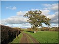
The Cumbria Way near Sebergham Hall
The cattle grid is on the track from Sebergham Hall to Bell Bridge which is a public bridleway and the route of The Cumbria Way (next photograph Image).
Image: © Adrian Taylor
Taken: 5 Nov 2017
0.10 miles
2
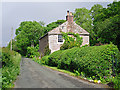
Deans Mill
The house sits between the road and the River Caldew. A map from 1900 shows a sawmill at this location.
Image: © Rose and Trev Clough
Taken: 21 Jun 2015
0.16 miles
3
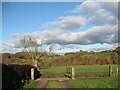
Cattle grid on The Cumbria Way
The cattle grid is on the track from Sebergham Hall to Bell Bridge which is a public bridleway and the route of The Cumbria Way (next photograph Image).
Image: © Adrian Taylor
Taken: 5 Nov 2017
0.23 miles