IMAGES TAKEN NEAR TO
Shaw Wood Road, CARLISLE, CA5 6QH
Introduction
This page details the photographs taken nearby to Shaw Wood Road, CA5 6QH by members of the Geograph project.
The Geograph project started in 2005 with the aim of publishing, organising and preserving representative images for every square kilometre of Great Britain, Ireland and the Isle of Man.

There are currently over 7.5m images from over14,400 individuals and you can help contribute to the project by visiting https://www.geograph.org.uk
Image Map
Images are licensed for reuse under creativecommons.org/licenses/by-sa/2.0
Notes
- Clicking on the map will re-center to the selected point.
- The higher the marker number, the further away the image location is from the centre of the postcode.
Image Listing (19 Images Found)
Images are licensed for reuse under creativecommons.org/licenses/by-sa/2.0
Image
Details
Distance
1
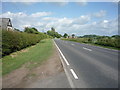
A596, Low Whinnow
Heading east towards Carlisle.
Image: © JThomas
Taken: 18 Jun 2016
0.02 miles
4
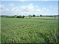
Entrance to farm on north side on A595 opposite Thresher Barn
Image: © Luke Shaw
Taken: 26 Apr 2024
0.10 miles
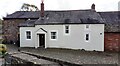
5
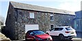
Barn conversion at Low Whinnow
Ordnance Survey documents describe a benchmark levelled at 96.786 feet above Liverpool Datum on the left hand corner (left hand face) of the building during the 1843/4 Kendal to Carlisle 1GL Survey. The surveyor's description was 'No. 356. Bolt in North-west corner of Mr. Fenwick's cow-house ; 2.98 ft. above surface'. It was subsequently levelled at 29.575m above Newlyn Datum in 1955 (verified 1969) with location described as NW angle north face of building at Low Whinnow Farm. The mark could not be seen.
However, the mark was subsequently found on the wall which can be seen in the left foreground of this image. See Image
Image: © Roger Templeman
Taken: 4 Mar 2024
0.14 miles
6
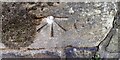
Benchmark on wall on south side of A596 at Low Whinnow Farm
1GL bolt benchmark with levelling information at Image
Image: © Roger Templeman
Taken: 26 Apr 2024
0.14 miles
7
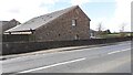
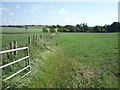
Barn conversion on south side of A596 at Low Whinnow Farm
There is an Ordnance Survey benchmark Image on the roadside wall on the line between the car bonnet and the cat's eye in the middle of the road
Image: © Roger Templeman
Taken: 26 Apr 2024
0.14 miles
9
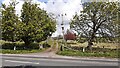
House at Low Whinnow Farm on south side of A596
There is an Ordnance Survey benchmark Image on the wall of the house at the left hand side of the image, beside a wooden gate
Image: © Roger Templeman
Taken: 26 Apr 2024
0.17 miles
10
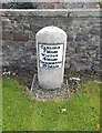
Old Milestone by the A596, Low Whinnow
Metal plate attached to stone post by the A596, in parish of THURSBY (ALLERDALE District), Whinnow, Private farmhouse, on South side of road. Carlisle red stone and curved plate, erected by the Cockermouth & Carlisle turnpike trust in the 19th century.
Inscription reads:-
CARLISLE
7 MILES
WIGTON
4 MILE
COCKERMOUTH
19½ MILES
Carved benchmark.
Milestone Society National ID: CU_CLCMa07.
Image: © Barbara Todd
Taken: 6 Sep 2023
0.17 miles