IMAGES TAKEN NEAR TO
East Park, CARLISLE, CA5 6PY
Introduction
This page details the photographs taken nearby to East Park, CA5 6PY by members of the Geograph project.
The Geograph project started in 2005 with the aim of publishing, organising and preserving representative images for every square kilometre of Great Britain, Ireland and the Isle of Man.

There are currently over 7.5m images from over14,400 individuals and you can help contribute to the project by visiting https://www.geograph.org.uk
Image Map (Loading...)


Getting Data...Please wait
Leaflet Map data © OpenStreetMap
Images are licensed for reuse under creativecommons.org/licenses/by-sa/2.0
Notes
- Clicking on the map will re-center to the selected point.
- The higher the marker number, the further away the image location is from the centre of the postcode.
Image Listing (4 Images Found)
Images are licensed for reuse under creativecommons.org/licenses/by-sa/2.0
Image
Details
Distance
2
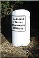
Old Milestone by the A595 at Howend
Metal plate attached to stone post by the A595, in parish of THURSBY (ALLERDALE District), Golden Acres bungalow, on grass verge, on South side of road. Carlisle red stone and curved plate, erected by the Cockermouth & Carlisle turnpike trust in the 19th century.
Inscription reads:-
CARLISLE
7 MILES
COCKERMOUTH
18½ MILES
Carved benchmark on top.
Milestone Society National ID: CU_CLCM07.
Image: © CF Smith
Taken: 8 Jun 2009
0.15 miles
3
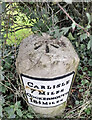
Old Milestone by the A595 at Howend
Metal plate attached to stone post by the A595, in parish of THURSBY (ALLERDALE District), Golden Acres bungalow, on grass verge, on South side of road. Carlisle red stone and curved plate, erected by the Cockermouth & Carlisle turnpike trust in the 19th century.
Inscription reads:-
CARLISLE
7 MILES
COCKERMOUTH
18½ MILES
Carved benchmark on top.
Milestone Society National ID: CU_CLCM07.
Image: © Barbara Todd
Taken: 25 Oct 2023
0.15 miles